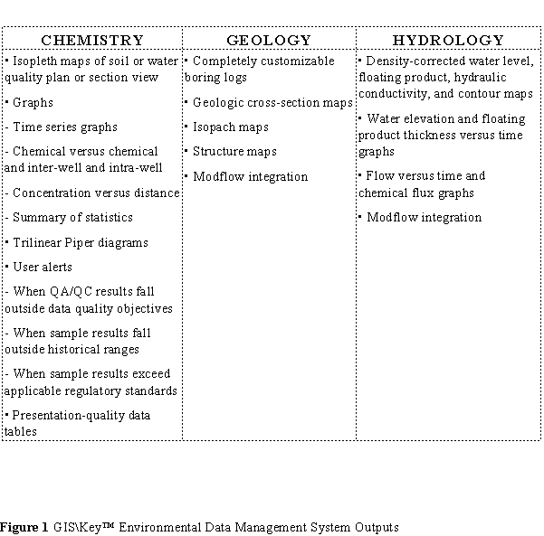
GIS\Key™ is a comprehensive environmental database management system that integrates site data and graphics, enabling the user to create geologic cross-sections, boring logs, potentiometric maps, isopleth maps, structure maps, summary tables, hydrographs, chemical time series graphs, and numerous other maps and line graphs (see table below). The software is menu-driven, making it relatively simple to use. All system outputs meet Resource Conservation and Recovery Act (RCRA) and Comprehensive Environmental Response, Compensation, and Liability Act (CERCLA) reporting requirements and are consistent with current industry practices.
GIS\Key™ can be a cost-effective tool to help manage hazardous waste site environmental data more effectively and accurately. GIS\Key™ allows project managers to focus on problem solving, because less time is required to enter, evaluate, and report the supporting site data. It also provides project managers access to environmental databases traditionally available only to computer specialists.
The GIS\Key™ software can be used at any Superfund site to facilitate the collection, reporting, and analysis of site data. The software is designed with numerous checks to assure the quality of the data, including comprehensive quality assurance/quality control protocols. System outputs, listed in the table below, are presentation-quality and meet RCRA and CERCLA reporting requirements. GIS\Key™ software includes an electronic laboratory import program that can immediately show where samples fall outside of historical data ranges, along with federal, state, and local action levels.
This technology was accepted into the SITE Demonstration Program in summer 1992. The demonstration was held in August 1993 in San Francisco, California, and December 1993 in Washington, DC. The Demonstration Bulletin (EPA/540/MR-94/505), Technology Capsule (EPA/540/SR-94/505), Innovative Technology Evaluation Report (EPA/540/R-94/505), and project videotape are available from EPA.
The GIS\Key™ software is in use at two Superfund sites: the Crazyhorse site near Salinas, California, and the Moffett Field site near San Jose, California.
The U.S. Air Force's Environmental Data Management and Decision Support working group is testing the effectiveness of the GIS\Key™ technology at Norton Air Force Base in California. The technology is also being used by consultants at over 20 other U.S. Air Force bases.
The GIS\Key™ software can directly export data into the leading three-dimensional visualization systems. These systems produce three-dimensional contaminant plume models and groundwater flow models as well as fence diagrams. GIS\Solutions, Inc., can provide an optional software module for three-dimensional modeling that runs on the Microsoft® Windows operating system.
Improper use of certain AutoCAD® commands can cause problems with basemap integrity. GIS\Key™ includes limited audit or transaction logging capabilities. GIS\Key™ data consistency and validity checks could be improved as it is possible to enter invalid data. Site data related to ecological assessment and air emissions is not managed by this software.
The goal of the SITE demonstration was to evaluate whether the software performs the functions claimed by the developer and assess the accuracy of the GIS\Key™ output. Also, GIS\Key™ procedures were reviewed to ensure data integrity, to evaluate the general usability of GIS\Key™ , and to compare GIS\Key™ features to user requirements.
Results from the SITE demonstration indicated that the GIS\Key™ software generated the four types of contour maps necessary to assist in groundwater mapping: hydrogeologic maps, chemical concentration isopleths, geologic structure maps, and geologic structure thickness isopach maps. Several advanced chemistry reports and construction and borehole summary tables were also automatically prepared using customized GIS\Key™ menu commands. The system automated well and borehole logs based on the information contained in the database.
GIS\Key™ provided several editable reference lists, including a list of regulatory thresholds, test methods, and a list of chemical names, aliases, and registry numbers.
The GIS\Key™ database menu provided commands for electronic database import and export. Any of the database files used by GIS\Key™ can be used with the general import and export commands available in the database menu.
EPA PROJECT MANAGER:
Richard Eilers
U.S. EPA
National Risk Management Research Laboratory
26 West Martin Luther King Drive
Cincinnati, OH 45268
513-569-7809
Fax: 513-569-7111
TECHNOLOGY DEVELOPER CONTACT:
John Saguto
GIS\Solutions, Inc.
1800 Sutter Street
Suite 830
Concord, CA 94520
415-827-5400
Fax: 510-827-5467