See acronym list; statutes follow horizontal lines.
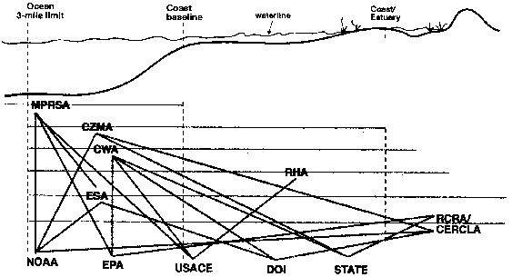
Source: 1997 NRC Report Figure 1-1 (see endnotes)
Figure 1. Agency and statutory responsibilities for
CS along the marine waterfront
See acronym list; statutes follow
horizontal lines.
Source: 1997 NRC
Report Figure 1-1 (see endnotes)
2.1 Identifying contamination and the decision to characterize
The diagram illustrates that responsibility for sediment issues in the marine waterfront voluntary setting is at best unclear. Further inland, states claim domain over inland waterways such as rivers and lakes, but the agency and statutory web (CWA, ESA, RCRA/CERCLA, RHA; NOAA, EPA, USACE, DOI, States) remains just as complex. Theoretically, phase I investigation results should provide the impetus for a sediment investigation during the succeeding assessment phases. However, constraints surrounding the voluntary and brownfield process often lead to minimal (surface grab), if any, sediment investigation—rather than a more preferable area-wide approach to redevelopment and assessment. The following scenarios illustrate why sediment sampling occurs less frequently in this setting:
|
For reference, nearly all CS cleanup on record comes primarily from Superfund, employing conventional dredging and disposal, capping, or stabilization methods. Though a number of innovative ex-situ treatments have been accomplished using dredged material, few in situ sediment treatment methods <http://clu-in.org/products/renhold.htm> have passed beyond the demonstration stage. Soon-to-commence beneficial reuse demonstrations will attempt to enhance the viability of navigational dredging, although debates continue about dredging's overall effectiveness as a remedial action tool. |
|
The state of Michigan uses the following priorities to recommend assessment and remediation grant funds under the Clean Michigan Initiative:
|
2a. Preference for institutional controls
Institutional
controls mitigate risks to humans, but leave contamination in place for
potential impact on biota and elsewhere. For many CS problems, regulators and
municipal officials will close off adjacent shallow groundwater wells or
surface water intakes, particularly if they serve small private water supplies.
In the event of toxin uptake through the food web, fish advisories and fishing
bans are implemented on an area by area basis. Beach closures and fencing off
the waterfront complete the list of commonly preferred control methods. With
the exposure pathways presumably closed and the policy satisfied, the
resolution in many cases satisfies the goal of risk reduction to human health
and the environment.
The area-wide concept, however, leads to questions about what constitutes good sediment sampling for an institutionalized property line mentality. The clear answer, barring a stable aquatic environment with minimal chance of contaminant and sediment transport, is that expecting an accurate picture under those constraints is unreasonable. From a legal perspective, since most states claim authority over their surface waters, only the landward soils need be accounted for in private cleanups—so long as contamination traceable to the property does not appear elsewhere during any later assessment work for different reasons. The odds of such assessment work occurring and such a link appearing, given the cost, environmental conditions, and boundaries of a future perceived problem seem slim. The contamination, however, remains in the environment, and is continually added to by pollution from surface runoff and industrial sources.
3a. Public ownership of waterway
Unless the state also
owns the waterfront property, an otherwise voluntary program for a private
landowner provides no requirement to sample aquatic sediment. The state's only
recourse is to reject such a property from the VCP or deny a NFA letter. Some
might argue that only select states would pursue this course of action.
Typically, the emphasis remains instead on soil and groundwater beneath the
property. Only with evidence of groundwater contamination and the potential for
subsurface flow into the water body via sediment would such an assessment
occur, likely under a different, mandated program. Action of that kind would
probably occur only if the contaminated groundwater impacted a water supply or
provided some additional threat to human health. In other cases, contamination
would likely go unchecked for an indefinite period of time.
3b. Public (city) ownership of property
City ownership of
the property may limit liability in some cases; however, the risk of becoming a
PRP does not completely disappear—an event that would commit resources
most municipalities do not have to the project. In many cases, in the words of
a Michigan project manager, "the cities choose to do the easiest sites first
and establish a track record, rather than deal with the more complicated
properties"16. This practice benefits the
municipalities by putting off any liability problems in the water, but leads to
questionable prioritizing among land parcels.
Brownfields projects in New Orleans, by no means the only ones to prioritize according to this system, provide some insight through a draft guideline point scale used in 1996. This scale was used to determine which brownfields in the federal pilot would receive funds for an expedited site assessment demonstration. Here, a previous round of ranking reduced the number of properties under consideration from 80 to 30. In this round, the guiding scale emphasis rests primarily on job creation and ease of redevelopment, with the highest-scoring properties generally receiving the greatest priority. One could surmise that the possibility of having to address CS would not assist a property under these criteria.
Table 2. New Orleans Brownfield Project Second Cut Evaluation Criteria - Draft Guideline
|
|
Due to sediment transport, relative location to a water body impacted by a CERCLA site may affect waterfront redevelopment. Under these conditions, disincentives exist for waterfront owners, particularly private owners, to voluntarily characterize their sites. These include:
Additionally, investigating offshore carries heavy disincentives depending on the status of the Record of Decision (ROD):
For these reasons, characterizing and assigning liability to the comparatively small share of sediment contamination that may arise from a single waterfront brownfield exceeds the scope of most state and local enforcement agencies. The cost of attempting to do so might well exceed the amount reclaimed. Additionally, other priorities clearly supersede it at the national agency level.
Yet without question, CS remains a problem in the nation's waterways that comprehensive liability laws struggle with, due to the lengthy process of identifying responsible parties. Under WRDA 92, the EPA's National Sediment Inventory identified 96 watersheds in the U.S. as areas of probable concern, where 75% or more of the sediment sampling stations indicated toxicity levels that posed at least some risk to human health17. This round of sediment sampling, the most extensive ever performed in the U.S., will have to be followed by additional sampling, though, to adequately characterize the problems and identify the highest priorities for cleanup within a watershed. For many locations, the waterfront voluntary setting - in cooperation with outside funding sources - may provide the only opportunity for such work in the near future.
2.1a Driving mechanisms for assessment
Brannon and McFarland (1996) identify three mechanisms driving sediment evaluation: impacts of dredged navigation channel sediments; environmental and human health impacts of existing undisturbed sediments versus natural recovery (usually in the context of an existing project for an identified location); and source identification and control18. These, together with a few other forces, comprise the primary institutional incentives to test for CS today. Other forces include spills or excessive releases from permitted facilities, sudden human health impacts, and reporting of abnormal conditions by outside parties.
With the exception of preventative source control, none of the above mechanisms causes a state or other agency, to go out and "look" for or at new CS. The CS at Black Lagoon, for the Detroit River/Trenton Channel beneficial reuse demonstration project, was discovered when a child experienced detrimental health effects and skin damage after walking in the water19. To this day, no viable PRP exists in the area, despite the heavy industrial footprint along the river and extensive ongoing mapping of CS in other river sections before the Black Lagoon discovery. This illustrates not negligence on the part of the agencies involved, but rather the limitations of science when asked to perform the difficult task of PRP identification and differentiation for a common resource with multiple pollution sources. The liability law imposes an incredible scientific burden to drive cost recovery; a burden which may be more easily met for some contaminants and some cases than others.
The result is the unfortunate situation of streams, rivers, lakes, bays, and other common waterways impacted by hundreds or thousands of point and non-point contaminant sources, with no means other than scarce, government-funded source control or baseline sediment mapping inventories to further characterize most of them. Although the most serious problems will ideally be addressed by the liability law and navigational dredging by the Corps (as industry tends to concentrate around navigable waterways), the time scale of the law and the lack of funded source control represented by these approaches will still leave future problems. Additionally, the assessment funding provided by navigation and USACE waterfront redevelopment projects is tied to a remediation method—dredging20.
For the remaining waterways, the potential CS problem remains largely uncharacterized and growing, though with less toxicity than in previous decades. An areawide, watershed-based assessment approach provides the best hope of addressing source control and determining where "hot spots" exist. It would also enable the EPA to make more judicious applications of the liability law, while truly solving contamination problems over the long term. In this sense, the Clean Michigan Initiative represents an epic shift in state-federal mindset and responsibility, where a state has volunteered to fund CS remediation in nine non-Superfund designated waterways, while retaining the right to pursue cost recovery against identifiable PRPs21.
As stated above, however, the voluntary or brownfield approach seems inadequate to address the problem by itself. The liability scheme, for its part, faces its own challenges, as the National Research Council notes that "it can take up to 15 years or more before a management strategy is put into place"22. Even under sediment cleanup standards, discerning responsible parties and determining investigation priorities will probably not lead to efficient cost recovery. In the meantime, CS continues to accumulate and impact the environment, though perhaps on a slightly smaller scale than before, with constant transport throughout the aquatic ecosystem.
2.2 Additional funding mechanisms to drive sediment assessment
To address the problem, local, state and federal agencies have had to shoulder an additional part of the cost recovery burden. However, by forming consortiums with private stakeholders in the waterfront voluntary setting, some groups have been able to address area-wide contamination problems and may recover, in the long run, some tax income that they may have lost by waiting for a 100%-liability based CS cleanup. Arguments will abound on all sides concerning whether or not the states, in particular, have the resources, cleanup and monitoring standards, and moral obligation to pursue this course23. Nevertheless, funding sources do exist for those willing to pursue area-wide cooperation.
2.2a Navigation projects and beneficial reuse of sediment
|
U.S. Army Corps of Engineers (USACE)—Waterways Engineering Station, Vicksburg, MS |
Navigable rivers and harbors tend to absorb the bulk of CS contamination, due to contaminant transport and industry concentration around these areas. A primary mission of the US Army Corps of Engineers involves developing and maintaining the navigable channels for these waterways. Because it lacks a line item in the federal budget, the Corps remains dependent on local representatives and other government agencies for work. It estimates that 5 - 10% of sediment in such channels is unsuitable for open water disposal under the Code of Federal Regulations (CFR)24. To solve this problem, USACE must theoretically use the least costly approach that complies with disposal regulations. Contracting parties must handle costs above and beyond that, though many cases cast doubt on the severity of that mandate25. The NRC recommends altering the policy for good to emphasize beneficial sediment reuse, because current government policy pays for risky open-water but not landward or beneficial disposal, an obvious disincentive to sponsors26.
The Corps has the authority under WRDA to clean upland properties if contamination migrates from them and impacts a navigable waterway, and brownfields provide suitable locations for beneficial reuse. Typically the sediment in the deep navigable channel does not pose a hazard—most contamination instead appears on the wings of the waterway. Therefore, clean or treated sediment dredged from the channel can cap landward soil contamination on waterfront brownfields, freeing them for reuse. One problem still under investigation, however, is that of microbes and contaminants in untreated fill sediments potentially entering the lungs via aerial exposure pathways.
This approach also leaves the problem sediment outside the channel unaddressed, since the work pattern has evolved this way over time, but the Corps has an interest in attacking that sediment as well. It could accomplish this by joining cooperative efforts, just as it invested heavily in cooperative beneficial reuse research when the number of available CDFs and CADFs began to shrink. Under WRDA, the Corps may dredge outside of the navigable channel to remove CS in other parts of the waterway. Though it has never used this power, cost sharing provisions might make it an attractive option to a port authority and/or state agency.
When the Corps does upland brownfield work for ports and cities, the cost sharing parameters make its involvement much easier than contracting privately, at least in the assessment phase, where the Corps only requires a municipality to cover 50% of the price. However, federal Brownfields pilot funds may not be used to pay the Corps, and additional work—costly if not accounted for in the federal budget—requires 100% funding by the client. Still, covering the upland assessments—which may comprise between 40 and 70% of brownfield redevelopment costs—would remove a sizable burden from municipal redevelopment agencies. Then, under an area-wide model, the Corps could re-enter the water and perform needed CS work and channel maintenance with a federal appropriation.
Recently, Dr. Tommy Myers of the USACE undertook a survey to gauge the demand for beneficial reuse of sediment on waterfront brownfields. Of 60 surveys sent out to ports and harbors around the United States, Myers received 20 responses—consistent with an earlier response that American Association of Port Authorities received when it queried its predominantly deepwater membership about brownfield redevelopment demand. Respondents, Myers notes, likely know of—or highly suspect—CS problems in their waterways, and seek assistance in balancing their desire for dredging and port expansion with the need to address contamination. With the prospect of EPA sediment standards, the Corps may investigate the possibility of a national sediment work strategy, with Congressional authorization and funding.
Table 3. Survey conducted by Dr. Tom Myers, USACE-WES, under Section 212 of WRDA 96
|
Statement 1: Contaminated sediments are a serious problem that impedes maintenance and development of port infrastructure.
Statement 2: Significant opportunities exist for coupling contaminated sediment remediation with waterfront brownfields redevelopment.
|
Finally, the Corps conducts research into field screening and assessment technologies for sediment, which are discussed later in this document, and will need demonstration projects in the future.
From an area-wide problem-solving perspective, a loan may provide the resources, but forming a public-private coalition with landowners will prove difficult if they will have to help repay the loan. This approach would only appear attractive if the landowners knew they might face CERCLA liability for impacting a common resource. In the waterfront setting, just such a complication arises when one considers the possibility of contamination not only in landward soils, but in adjacent aqueous sediment as well. Therefore, cooperative agreements among multiple stakeholders that cut across regulatory programs and interests—most often navigation, voluntary cleanup, brownfields, and mandated or liability-driven actions—have proven quite successful at securing funding.
The key to effectively utilizing a loan approach likely involves a combination with grants or other funded projects at the state or federal level. This allows the consortium to address multiple area-wide contamination concerns, particularly regarding upland sources and impacts on wildlife. To property owners nervous about investigating their land, such grants and projects indicate a commitment to solving overall environmental problems rather than simply forcing PRPs to assume costs for a sediment project with an indeterminate scope. This is not to say that the PRPs have to "get away" with their pollution for the cooperation to work. In Bellingham, for instance, Washington's Department of Ecology conducts ongoing State Superfund work in a region that has been well mapped for CS for many years. There, Ecology addresses the most severely affected area—the Whatcom Waterway—through Superfund, while its grant-funded consortium with the Port of Bellingham addresses CS in the inner bay. Additional upland voluntary cleanups in conjunction with CS remediation would also recover some costs for the state.
As stated above, the federal Brownfields Initiative, along with most states, provides Revolving Loan Funds (RLFs) Other loan opportunities are available at the state and federal level, however, and one with particular importance for CS and brownfields may expand in the near future.
The Clean Water State Revolving Fund (CWSRF) takes in state and federal contributions, and then pays out low or no-interest loans for water quality projects. Each state, as well as Puerto Rico, has a CWSRF program linked to the fund. Currently, it holds over $27 billion in assets, providing about $3 billion worth of water project support annually27.
For brownfields, the CWSRF can fund projects that would mitigate or even eliminate aqueous sediment pollution problems. According to a recent memo, CWSRF funds could cover at least the following tasks28:
Although the states determine project eligibility on an individual basis, most likely anyone qualifying for a VCP program will also qualify for CWSRF funds. The terms of the loan could provide a much needed incentive for waterfront brownfield owners to assess and clean up aqueous sediment, particularly if the owner is a municipality seeking to address wider water quality issues. In some cases, CWSRF proponents note that a loan may provide a better deal than a grant that requires cost sharing29.
In addition, the Administration proposes to earmark 20% of CWSRF funds in its FY 2000 budget for "non-point source and estuary project grants." With a budget request of $800 million, this could amount to approximately $157 million in grants. On an individual project, these grants could cover 60% of the costs, with the remaining 40% paid by a no-interest CWSRF loan or other specified financing sources30.
2.3 Post-characterization risk assessment for sediment
Image Source: Hart-Crowser, Inc. 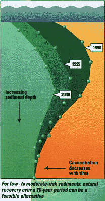 Risk
analysis rests at the core of CS problems, due to their widespread nature. For
many sites, although contamination may spread throughout a waterway, removal or
treatment of all CS is both impractical and unnecessary. Under such procedures,
low-level pollution may accumulate or have uncertain impacts on the environment
and go both unassessed and unremediated due to a lack of distinguishable PRPs
and direct threats to human health. Such questions, however, address matters of
responsibility and cost recovery, and the fact they remain unresolved to this
day emphasizes how a risk-based approach has helped to expedite the actual
cleanup process while the debate continues.
Risk
analysis rests at the core of CS problems, due to their widespread nature. For
many sites, although contamination may spread throughout a waterway, removal or
treatment of all CS is both impractical and unnecessary. Under such procedures,
low-level pollution may accumulate or have uncertain impacts on the environment
and go both unassessed and unremediated due to a lack of distinguishable PRPs
and direct threats to human health. Such questions, however, address matters of
responsibility and cost recovery, and the fact they remain unresolved to this
day emphasizes how a risk-based approach has helped to expedite the actual
cleanup process while the debate continues.
For CS, risk and cost/benefit analysis channels resources toward greatest efficiency in the remediation phase. Smaller, high-risk "hot spots" may require more expensive and more complicated solutions; larger, low-risk areas often allow for less expensive methods or natural recovery. The NRC notes, however, that more risk and cost benefit analysis needs to address "risks of sediment removal or relocation or the risks remaining after remediation"31.
While diminishing returns serves as the law of risk analysis, quality standards used to evaluate those risks "have not been linked quantitatively to ecological or human health risks," the NRC states32. From a policy perspective, the preventative principle should drive such decisions; however, the NRC statement gives powerful ammunition to those with an incentive to oppose sediment quality standards out of liability fears. If EPA attempted to promulgate such standards without Congressional authority, it face a legal conflict similar to its Clean Air Act air quality standard revisions, recently struck down by a Federal District Appeals Court33.
2.4 Potential impact of prospective EPA Contaminated Sediment Standards on assessment
Image Source: Hart-Crowser, Inc. 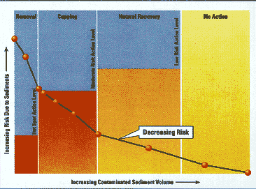
What level of risk, though, translates into a quantifiable standard that determines the next step in the cleanup process? As stated earlier, the waterfront voluntary setting provides, in many cases, the only near-term opportunity for sediment assessment in a municipality. Unfortunately, under the present system, assessing CS responsibility without an imminent threat to human health proves difficult—which means that costs of proceeding further cannot be recovered. With the EPA pursuing maximum toxicity standards for sediment, the question of payment for assessment and cleanup has the potential for increasing legal conflict, depending on the rigor of the standards. However, the end result could provide a better benchmark to determine the need for and success of CS cleanups. Projects to date have tended to address toxic "spot contamination" already in place, rather than genuinely addressing issues throughout the watershed, such as surface runoff, because non-NPL CERCLA cleanups lack that authority34. Again, the question becomes one of funding, in this case, money that the liability law does not allocate for such preventative purposes.
Any new sediment standards will strongly drive technology use in the aquatic environment. Under such regulations, sampling tools would have to meet stricter data quality objectives for the quality criteria contaminants, although sediment usually contains multiple contaminants that the criteria might or might not cover.
Currently, dredging or grab sampling from the top of sediment layers risks cross-contamination and remains subject to forces in the water column. It also ignores leaching and does not provide indication of contamination depth. The much more common coring techniques usually have limited core lengths and unrepresentative interior diameters, also making it harder to collect a high quality sample. Furthermore, the NRC labels coring as "slow and expensive," and, depending on site-specific conditions, as "provid[ing] limited spatial resolution"35. Fortunately, on the assessment side, although this report uncovered no full-scale field screening or on-site analysis applications for aquatic CS, better versions of the core samplers themselves will enter the market soon. Combined with the wide range of bench-scale screening technologies and improving lab analysis instruments, at least the cost of assessment will fall, while its effectiveness rises.
2.5 Emerging field screening and sampling technology for CS
Rapid Sediment Screens, developed and tested by the USACE, could save money and provide a more accurate description of the contamination zone for CS. Though the technology relies on an extraction step that must occur in a lab, it still saves money by signaling non-detect samples, providing a chance for additional coring near positively identified contamination. Like most screening technologies, the methods work only for single sediment contaminants (i.e., biomarkers for dioxin in CS), and, unfortunately, their use remains unacceptable under CFR. The Corps has also expressed concerns about its ability to transfer sediment screening technologies from its labs, and would do well to follow the example set by the Bay Area National Laboratories and the Region 9 Environmental Finance Center36.
The AMS Split Core Sampler for Submerged Sediments, recently demonstrated under the SITE Monitoring and Measuring Technology program, collects cylindrical cores to a maximum depth of 36 inches below the surface. AMS created the tool by modifying its existing Split Core Sampler for soils. Two key differences between its design and that of conventional sediment corers allow it to provide a higher quality sample. A ball check valve in the top cap allows water to exit during submersion and creates a vacuum to hold sediment in during retrieval. The modified coring tip contains a basket retainer to hold sediment within the interlocking split core cups. AMS hopes that these modifications will address concerns about conventional coring and lead to more sampling of undisturbed zones not sampled through grabs or dredging. For more information, see the Contacts table or SITE Program Demonstration Bulletin EPA/600/F-99/008.
The ARI Russian Peat Borer, originally used for collecting microorganisms in pond sediment, was also recently demonstrated under the SITE program. Along with the AMS Sampler, it successfully collected PCB and arsenic impacted sediments from the Fox River and Dothan Park in Wisconsin and Mystic Lake and Woburn in Massachusetts. The Peat Borer can operate in water depths up to 15 feet, and can collect samples as large as one liter as far down as 65 feet below sediment surface. Borer materials are lightweight, durable, corrosion resistant, and strong. Used in parallel, two borers provide a complete, continuous sediment core, with little surface disturbance and no sediment entry during the driving process. For more information, see the Contacts table or SITE Program Demonstration Bulletin EPA/600/F-99/008.
NRC Report comments on site characterization needs for contaminated sediment
Problems
|
[ Back to Chapter 1 | Forward to Chapter 3 ]
15Clean
Michigan Initiative. Michigan DEQ, Lansing, MI, 1997.
16Personal Communication, Mr. Chad Howell, City of
Kalamazoo, MI. June 1999.
17The Incidence
and Severity of Sediment Contamination in Surface Waters of the United States -
Volume 1: National Sediment Quality Survey (EPA/823/R-97/006). Office of
Science and Technology, EPA, Washington, DC, April 1997.
18Brannon, J.M.; McFarland, V.A.
Technical Considerations for Sediment Quality Criteria.
Miscellaneous Paper W-96-1. Water Quality '96: Proceedings of the Corps of
Engineers 11th Seminar on Water Quality, Feb. 26th-Mar 1st, 1996, Seattle,
Washington. USACE-WES, Vicksburg, MS, 1996, pgs. 346-352.
19Personal Communication, Mr. Art Ostaszewski, Michigan
DEQ.
20For two very different perspectives on
dredging, consult the
USACE
E2-D2 page and
GE's
HudsonWatch page.
21Clean Michigan
Initiative. Michigan DEQ, Lansing, MI, 1997, p. 8 of online edition.
22NRC Report:
Contaminated Sediments in Ports
and Waterways: Cleanup Strategies and Technologies. Bokuniewicz, Henry, et
al. National Academy of Sciences, Washington, DC, 1997, p. 5.
23For more on state-federal cost recovery issues, see the
Testimony of Ms. Claudia Kerbwy, ASTSWMO, March 23, 1999,
before the House Commerce Subcommittee on Finance and Hazardous Materials.
24NRC Report, p. 1.
25Personal Communication, Mr. Tommy E. Myers, Ph.D., June
29, 1999.
26NRC Report, p. 171.
27Internal Document: "Special Report: Funding Brownfield
Remediation with the Clean Water State Revolving Fund." Report from Kristin S.
Kenausis, Communications Specialist, State Revolving Fund Branch, EPA Office of
Water, July 1999.
28Ibid.
29Personal Communication, Ms. Jennifer Millet, EPA-OSPS,
meeting with Mr. Andrew Kreider and EPA-TIO representatives, June 1999.
30These and preceding statistics in paragraph from
"Special Report: Funding Brownfield Remediation with the Clean Water State
Revolving Fund."
31NRC Report, p. 42.
32Ibid., p. 42.
33See
American
Trucking Associations vs. U.S. EPA, May 14, 1999, and the
Federal
Response.
34See
http://www.epa.gov/superfund/whatissf/cercla.htm
35NRC Report, p. 73.
36Personal Communication, Mr. Tommy E. Myers, Ph.D., June
29, 1999.
Page last modified: