|
3. Current Application of Innovative Characterization Technology at Waterfront Voluntary Sites |
3.1 Methods of data collection
Site specific information
To gather site-specific technology application data on brownfields and VCP properties, one must rely almost exclusively on intra-governmental documentation and chain-of-command interviewing. Factors limiting the effectiveness of this approach include time, resources, and access to the decision-makers involved.
Unlike Superfund and RCRA, brownfields technology use for both characterization and remediation is generally not subject to documentation requirements. Public records of decision (RODs) do not exist for these projects, and EPA headquarters does not keep regular tabs on individual federal pilots. Most of that information resides at the regional level of the Agency or with individual project managers. While state VCPs must track individual parcels by the nature of their programs, most do not track technology use. Finally, large amounts of information remain confidential to non-agency and non-government employees.
Therefore, access to documentation on technology use largely depends upon the lead agency and the researcher's relationship to it. The following points summarize the common information access paths used in this report:
3.1a National Brownfields Assessment Pilot (Federal Pilot) properties
3.1b - State voluntary cleanup and brownfields programs
3.1c General exceptions and advisories for data collection
Since characterization and remediation phases are usually bid separately, this creates the possibility of two or more firms holding information on a single redevelopment project. Fortunately, the remediation contractor ends up with data from the assessors, and may obtain reports from surrounding properties depending on the requirements and professional quality of the job. If, however, the property is under consideration for mandated corrective action, assessment contractors usually will not share characterization information for confidentiality reasons.
3.2 Decision making in the characterization tool selection process
The final decision to use field portable technologies in the voluntary setting usually rests with the agency project manager, who usually relies on the consulting engineer. This reliance may manifest itself in an "enhanced review process," but no amount of streamlining will compensate for an overly rigid policy that hinders field tool application. The several sets of factors noted above constantly impact, dilute authority among, and affect the decision-making within this relationship. The overall approach presents several problems.
First, the project manager is often over-reliant on the engineer. Workload and lack of technical expertise, as well as hesitancy to deviate from standard procedure, causes the agency representative to assume an approve/disapprove posture. If the consulting engineers can show that their sampling plan meets agency policy requirements, regardless of whether or not it may provide the best quality, most efficient, or most appropriate data, then it satisfies the firm's burden. Keep in mind that data quality objectives or other means to ensure quality control are relatively new to some states.
From a documentation perspective, the process of devising a characterization plan and selecting tools and technology remains relatively opaque. Some observers at the federal level have noted that the informational and creative burden on the firm not only proves efficient amidst limited agency resources, but helps deflect accountability as well. Any mistake or undetected contamination becomes the fault of the contractor.
The firm, which may have its own motives and those of its voluntarily acting client to contend with, is left to advocate its plan before the regulators (known as "providing a deliverable"). Unfortunately, some firms hesitate to apply innovative characterization technologies, either due to poor cost/benefit information for the client or an uncertain performance perception. Without an open policy that efficiently permits and effectively promotes innovative alternatives from the start, the state regulators will end up approving plans that meet their conventional sampling criteria. Less than effective and less than efficient site characterization results from this cycle, particularly in light of the unique needs of waterfront property and brownfields stakeholders.
Agency attempts to push an innovative technology at the approval stage — with inadequate resources to review each plan, select the proper technologies, and incorporate data quality objectives that may not have been designed with innovative tools in mind—would only draw out the process and alienate VCP participants. Unfortunately, in the voluntary and brownfield process, most states do not get involved until this point, leaving the assessment work to the client and firm. This places the burden on them to step forward and "claim" a status for their property, whereupon the state determines the necessity of and verifies cleanup actions.
Due to this market's preferences noted above, and despite state pressures, field portable tools should theoretically appear frequently throughout the dataset. Longtime observers of brownfields and the environmental assessment technology market, however, know all too well the problems with the above statement. These problems include overly rigid state policies regarding innovative technology, as well as traditional obstacles noted in Section 1.6. Because of the national nature of this project, it seems futile to explicitly predict if field-based characterization tools will experience more or less application than conventional tools. The distribution and concentration of sites among the states would skew the data and mask the large impact of state agency policies on sediment assessment and technology use. Without explicitly comparing every state and EPA regional policy, it remains difficult to predict whether the pilot sites or VCP sites will exhibit greater use of these tools.
The voluntary waterfront redevelopment setting, with its tight budgets and short time frames, lacks tolerance for technical mistakes. Therefore, the data on innovative characterization tool application for this setting should support a few conclusions:
A large percentage of information in the data tables, specifically the Contact data tables, contain hyperlinks to web pages or email. This was by design, as the data tables are meant to serve as a resource for researchers in addition to simply providing information for this project. A stable dataset compiled over time is necessary to both accurately gauge progress and identify problem areas with voluntary cleanup programs. For our waterfront subset, it provides the opportunity to test the impact of various policy programs, redevelopment theories, and political proposals. With finer examination, it also shows a great deal about the organizational structure behind implementing these programs, how it works, and where connections need to be made or strengthened. More work needs to be done, and with scarce information on site specifics for the voluntary market, these tables represent a starting point that researchers will hopefully build on, cite, and communicate their ideas with.
Data collected directly support assumptions one and two, and with few exceptions, also support the third assumption.
Data Tables (Appendix A): Data Matrix, Contact List, and data tables for 115 sites on the following topics: Oversight, Progress, Field Tool Application, Contaminants, Remediation, Sediment Assessment, and proximity to NPL.
Contaminant Classes at Selected
Waterfront Voluntary Sector Properties
A large percentage of information in the data tables, specifically the Contact data tables, contain hyperlinks to web pages or email. This was by design, as the data tables are meant to serve as a resource for researchers in addition to simply providing information for this project. More work needs to be done, and with scarce information on site specifics for the voluntary market, these tables represent a starting point that researchers will hopefully build on, cite, and communicate their ideas with.
Site selection
Waterfront location was the primary criteria
for site inclusion. Secondary criteria included planned or completed work and
identification as a targeted property under a Brownfield pilot. Inclusion was
slightly biased to collect as much information about properties that had
completed phase II work in as short a time as possible. Since properties were
followed up on immediately once identified—the dataset had to be created
from scratch within a 12-week time constraint—it seems obvious that
waterfront sites with complete site characterizations would prove of more
interest than those without. For that reason, this paper does not provide a
nationwide "universal status report" on all waterfront voluntary
properties.
Contacts
Most information for this project was collected over
the phone or via email. The idea of voluntary submission via a web-based form,
database, and possibly GIS seemed appealing; however, the State of Pennsylvania
has tried exactly this approach for gathering less technical information than
contained in this report. Their result, 21 sites, has been supported by a grant
program that pays local government entities $1,000 per brownfield they submit
to the voluntary database38.
At the time this project began, the EPA volunteered no centralized nationwide contact list for brownfields project managers, and one may not exist. Contacts listed on the scant fact sheets were at times out of date and rarely the best persons for the information sought here. Nearly all of the site contacts listed with this report were contacted over the phone and/or via email. As this was in some ways an on-the-job learning process, there were no "standardized" questions, though certain topic headings always were covered depending on the contact's expertise and access to relevant site information — these comprise the data tables. A fair amount of information not included in this report was also collected, as project managers and engineers tend to relate background knowledge and unique challenges facing their sites as well.
Below the site contacts are a list of other contacts, all experts in their particular field whose insight was invaluable in shaping portions of this report. The contacts file also includes a linked list of online state databases explicitly containing or searchable for voluntary properties. One of the major drawbacks of the Kensington Report was its failure to include a list similar to this. Finally, the contacts file concludes with contact info for firms and others that deal extensively with voluntary industrial cleanups.
Progress
One large drawback with this table involved
groundwater testing; because the project's intent focused on obtaining
information field-based characterization tools, some sites focused their
information-providing efforts on soils and sediments. Though data gaps exist
with regard to media, it seems clear from industry protocol that the vast
majority of sites that have sampled soils have probably also sampled their
groundwater. With additional time, a firmer correlative link could have been
established between sites sampling (or not sampling) groundwater and sites
sampling (or not sampling) sediment. In this way, analysis of the groundwater
leaching contaminant pathway could occur.
Field-portable tool application frequency
Clearly, from the
descriptions above, determining a progress of a site proved many orders of
magnitude easier than accessing field tool information. However, 21 sites did
apply field-portable screening or analysis technology, and an additional five
used only Geoprobe or direct push methods, which still fit the definition of
field tools despite their non-innovative qualities and established market
position. Among the sites applying innovative methods, handheld photoionization
devices (PIDs) and soil gas samplers, both screening tools used to better
define regions of contamination, were the most common choices. A total of 15
PIDs, used mainly to detect VOCs, and 6 soil gas samplers, were employed. Four
sites chose to use on-site labs, including one private site outside of the New
Orleans federally funded demonstration, a former explosives plant in DuPont,
Washington. The Navy, with its sizable in-house research division, has taken
the lead in applying innovative field technologies to its sites—though
even under base-closure conditions, it operates under a different set of
funding and market parameters.
In time, additional follow-ups or data contributions will allow us to obtain a more accurate picture of exactly how many sites nationwide employ field tools and for which purposes (screening or analysis). For now, due to state policies and communication gaps regarding on-site analysis' reliability, screening tools experience far more widespread application. Screening frequency with the tools noted is consistent with the high number of sites reporting VOCs, though the high number of sites reporting heavy metals would lead one to expect high frequency in XRF application as well, to counter the large cost of soil removal. XRF, however, saw rather limited application in the waterfront voluntary setting.
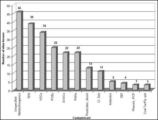
Contaminants
No particular type of waterfront industry was
targeted by this report; as a result, the dataset reflects a wide variety of
contaminant classes from many different industrial and, at times,
non-industrial sources. The most prevalent contaminants in sediments, however,
included traditionally common materials such as PCBs, PAHs, pesticides (dioxin
in particular). VOCs, metals, and TPH were the dominant contaminant classes in
landward soils. Where groundwater information was available, TPH appeared to be
the primary contaminant.
Remediation
A few innovative remediation projects eventually
appeared among the 115 sites. As one can determine by comparing the number of
phase II completions to the number of completed remedial projects, however,
most voluntary and brownfield projects that might take advantage of such
technologies have not yet reached this stage. Presently, two conventional SVE
projects, as well as one combined bioremediation and thermal desorption
project, are operating in Portland, Oregon. Several natural remedies provide
hope for cost-effective, low-impact solutions on the horizon—plans for
wetlands at Pittsburgh's Duquesne Slag, and plans for phytoremediation at
Brownfields pilots in Danbury, CT and Hennepin County, MN.
Sediments
The sediment data makes clear that CS assessment is,
in most voluntary cases, directly supported by a public funding source. This is
consistent with its status as a common resource and the lack of a viable cost
recovery option through the liability law, for reasons cited in Section 2. The
vast majority of properties with known sediment assessment work accomplished it
through a CERCLA investigation (13) or with assistance from the USACE (8). The
two Danbury properties, the Stockton property, and the Pittsburgh property had
municipal assistance with the cost recovery. The Harlan, OR and White City, OR
properties participated in a Targeted Brownfields Assessment sponsored by EPA
Region 10. The two Bellingham properties were part of an innovative partnership
that seeks to address CS and other pollution issues surrounding Bellingham Bay.
One site has applied for state funding. Only two properties uncovered in this
report—ASARCO in Omaha and the Lake Union Steam Plant in Seattle—show
evidence of voluntary, privately funded sediment assessment work.
As for the sites that did not assess, some had their reasons. The New Orleans Brownfields pilot, for instance, suspected only TPH in the groundwater at its sites, based on earlier phase I information39. Pacific Bell Park in San Francisco, although built on a waterfront site with an industrial past, needed only to address lead contamination associated with fill material in the soil. Other sites, like those in St. Joseph, MI, await funding from state and federal sources. Still others, like the properties in Channelview, TX or Shreveport, LA, were not part of a wider redevelopment plan or cooperative partnership similar to St. Joseph's, and therefore had no incentive to investigate what is likely an extensive multiple source CS problem in their heavily industrialized areas.
3.5 Cases
Due to the variety of field-based characterization tool application found in this report, as well as the divergent needs of environmental professionals, those seeking further background for case studies should consult the dataset (Appendix A) and contact the sites of interest to them. In addition, it would be advisable to note the future research needs listed in Section 3.6. Case studies were compiled for sites that addressed area-wide concerns (most often CS), because of the potential market for field-portable sediment assessment tools and the ability of cooperative partnerships to expedite assessment while confronting multiple environmental and financial issues.
Confronting area-wide concerns
A cooperative partnership in Bellingham, Washington has provided an example of how area-wide sediment assessment might occur under the current regulatory framework. A 3-year effort among 14 state and federal government and industry partners has recently produced a draft EIS identifying sediment cleanup alternatives for Bellingham Bay. Included in the partnership are several industries responsible for sediment pollution in the bay, including Georgia Pacific West.
The partnership seeks to streamline the necessary sediment cleanup, but also address wider issues associated with the health of the bay. These issues include source control, habitat restoration, and plans for future surface water and shoreline land use.
Under a CERCLA-mandated cleanup decision, sediment problems would eventually be addressed, although wider watershed concerns might not. The advantage of PRP liability would reimburse taxpayers, but probably over a longer time frame. The Bellingham Bay partnership provides a way to address aquatic sediment problems more quickly by supplying the most important element needed for sediment assessment—a secure source of funding. For this pilot project, a variety of agencies, including EPA and the Washington State Department of Ecology, provided grants.
It should also be noted that one shoreline property—the Olivine Property—had sediment assessment undertaken for in water construction at a Coast Guard base. The Coast Guard paid for the work on that project, and is also a member of the Bay partnership.
Significantly, Washington State remains one of the only states with sediment quality standards. Projects like the one in Bellingham Bay may illustrate how such standards lead to addressing wider watershed environmental problems. From a decision making perspective, Ecology knew that bay sediments were likely contaminated with a variety of contaminants from several sources — and that some areas probably exceeded the standards. Community support for rehabilitating the waterfront and preserving existing employment opportunities was strong; however, the process driver—environmental assessment to determine what actions were needed—was missing until Ecology stepped forward with the grant. Both the Bellingham Bay Demonstration and the Bellingham EPA Brownfields Pilot have been notable for their public and private stakeholder involvement. As a result of this cooperation, sediment assessment was conducted in less time than on average, and necessary cleanup to a defined standard will commence soon. When the sediment project and Brownfields pilot conclude, the wider bay ecosystem will fare much better than it has over the past half-century and the city will have a cleaner, revitalized waterfront.
The only limitation on this type of cooperative agreement remains the policy question of having the taxpayers assume the burden for pollution caused by a multitude of responsible parties, only some of which the liability process can identify and distinguish relative culpability among. In terms of end results, however, the Bellingham project, by addressing shared concerns and multiple interests—from wildlife to redevelopment—has produced an effective model.
Seattle, WA—Multi-User Disposal Sites (MUDS)
Another innovative sediment project from Washington's Department of Ecology involves disposal sites for dredged material. The Seattle office of the USACE is working with EPA and Ecology to study aquatic, nearshore (cap/fill), and upland disposal sites. USACE has particular interest in this project since, as discussed above, it has wide authority to address CS in and around navigable waters. The most innovative part of the project, however, allows both public and private dredging projects to use and pay for the disposal sites. Though the overall financing and cost sharing requires more discussion, the concept of establishing a permanent, safe, and accessible disposal option looks promising. Though in situ treatment would provide a more guaranteed environmental outcome (rather than transporting the problem and dealing with dredging's inadequacies), it remains undesirable from a cost, permitting, and practicability standpoint for multiple stakeholders. For the present needs of the area, which involve known CS and needed—perhaps even mandated—dredging, the MUDS project appears appropriate.
Emeryville, CA—Soil and Groundwater
Emeryville has undertaken an area-wide approach to assessing soil and groundwater by sampling and monitoring throughout the city and the near-shore region of San Francisco Bay. Though comprehensive sediment assessment did not occur, near-shore groundwater monitoring well and grab samples were taken to determine if contaminated water might threaten the Bay. Because of the large number of brownfields and potential contamination sources, transcending the property line approach was made easier in this case. However, aquifers are always common property resources that transcend property boundaries, and Emeryville's willingness to take the area-wide approach illustrates once again the driving forces behind environmental cleanup.
The city's action only appears exceptional because it occurred under a process that emphasizes property lines for the sake of redevelopment. The fundamental ideals behind revitalizing and redeveloping Brownfield parcels break down, though, if the contamination issues associated with them multiply among or impact a large area. To clarify, this is not so much a problem with the program itself, but with the resources presently committed and available to redevelopment entities—specifically municipalities. Cities in general view the legacy of contamination as a property-specific problem that disappears when the land is remediated. They cannot usually commit to investigating common property resources like aquifers or aqueous sediment, because they lack either statutory authority or adequate funds to do so. Private redevelopment entities, clearly, have little interest in becoming tied to a problem with an unclear definition of responsible parties. Additionally, because other municipalities may have contributed to the problem, the issue falls to the states—who, for reasons of their own, as in the case of CS, have established funding priorities (see the Clean Michigan Initiative criteria, Section 2.1).
In that light, Emeryville's initiative appears particularly remarkable. Adequate funding served as the key driving force, allowing the project to assist rapid redevelopment, as an entirely clean city proves more attractive than one with only a clean section or a clean corridor.
In Portland, ODEQ completed area-wide sediment sampling because of CERCLA-related concerns about several sites along the Willamette River. For more information, please refer to the linked Portland Harbor Sediment Management Plan linked above.
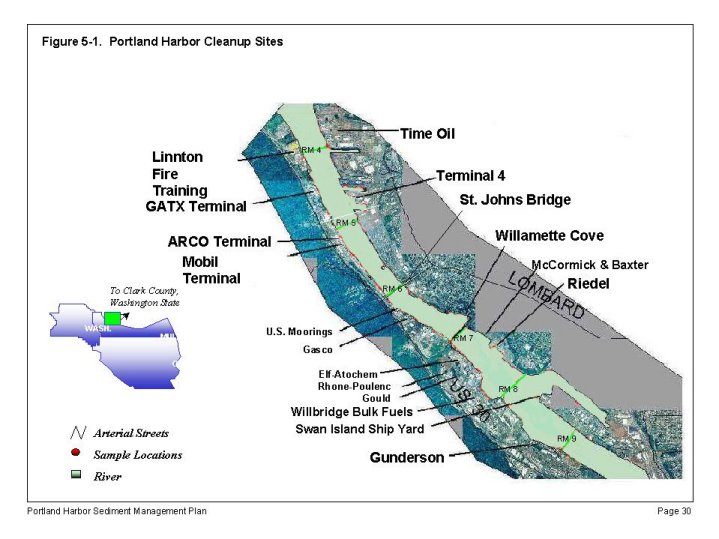
Source:
ODEQ
Portland Harbor Sediment Management Plan
Interim Action
Hennepin County, MN—Chemical Marketing Corporation
If emergency-response requiring contamination does not exist on a site, utilizing pre-emptive phytoremediation may improve its market value. Often, a site owner cannot pay to clean up contamination and must rely on a buyer to steer the property through voluntary cleanup. However, the owner usually does not want to abandon the property and would like to receive some compensation for giving up the land. Planting trees and plants, and removing debris, can dramatically increase the attractiveness to a buyer, while helping to remediate some metals and providing a higher sale price for the owner. Admirable public involvement and education has occurred as a result of this federal pilot. Additionally, unlike some pilot locations, the community has chosen to address a more difficult State Superfund site and take a large step, rather than a tiny one, to generate momentum in their brownfield redevelopment process.
Beneficial Reuse Demonstrations
WRDA Sediment Decontamination Project
A shortage of aquatic disposal facilities caused several agencies with responsibility for the New York/New Jersey Harbor area to investigate beneficial reuse treatment technologies. These technologies would treat CS unsuitable for open water or CADF disposal. With support from the 1992 and 1996 Water Resources Development Acts, the USACE, EPA Region 2, and NY/NJ Port Authority will evaluate the BioGenesis Sediment Washing, IGT Thermal Cement Lock, and Westinghouse Vitrification methods in a series of four demonstrations. The BioGenesis pilot-scale projects, for one example, range in size from 500cy to 500,000cy and will conclude around 2002. The consortium hopes that the WRDA project will eliminate a sizable part of the harbor's CS problem, while the port deepens channels that will allow the area to compete for deep-draft container ship traffic. The port has set a cost ceiling of $35 per cubic yard for treatment, a large reduction from the average $200 per cubic yard, guaranteeing that the technologies emerging from the program will provide a good turnaround on investment.
Detroit River, MI - EPA Region 5 and Michigan DEQ
Following an initial bench scale study of five remediation technologies applicable to both inorganic and organic contaminants, Michigan DEQ ended up satisfied with the same three methods as the WRDA New York/New Jersey project. From these three, Michigan selected the Institute of Gas Technology (IGT) Thermal Cement Lock process as the most marketable technology with the greatest potential for reuse, and has partnered with EPA Region 5 for upcoming pilot scale work with that process. IGT received a grant of $200,000 to find a site for its 30,000-cubic yard kiln apparatus along the Black Lagoon/Trenton Channel adjacent to the Detroit River. No viable PRP exists for this location, no redevelopment is anticipated due to the severe contamination, and institutional controls such as fish advisories remain the only actions taken at this particular location. However, Region 5's R/V Mudpuppy completed extensive sediment assessment work on this stretch of the river, adding to a 20-year store of CS knowledge. Officials remain very optimistic that the beneficial reuse prospects for dredged material will allow them to recover costs that the absence of a PRP would otherwise prevent. Additionally, they hope that the turnaround value of the process will prove attractive in the voluntary setting, as the IGT process can handle a wide variety of wastes, from TOSCA material to brownfield soil.
3.6a Cost/benefit analysis needs
For landward soil characterization technologies, most of the technical information (e.g., how the tool works, why it works) is available from the references listed in the Contacts or Verification tables accompanying this document. Some of the technologies are recognized as fundamentally sound by other scientific disciplines, such as gas chromatography, while others have experienced at least limited application in a setting where one could record cost information. The balance of the landward tools, as well as all of the sediment assessment tools, remain in the bench or pilot scale stage.
Most of the cost information remains inaccessible, however, since that type of documentation exists only between the client and the firm. An agency would not keep track of that data unless it was paying for the work through a grant or targeted assessment program. It seems clear that the case for innovative site characterization technologies would receive a large boost if more cost/benefit analysis occurred, with comparison to conventional characterization methods. The best-cited examples so far, however—the Expedited Site Characterization Demonstration properties in New Orleans, LA, Brownfields pilot—faced their own field problems, which had little to do with the accuracy of the instruments40. One may also find the following generalized data useful41:
|
Item |
General Sampling Cost |
|
Labor rate and Handling costs |
$35/hr plus $10 per sample, respectively |
|
Soil Collection |
$10 per sample (hand); $600 per day + $30 per sample (Geoprobe) |
|
Groundwater Sampling |
>$40/sample plus well installation costs |
|
Sediment Sampling |
$30/sample (shallow), + equip. cost (deep water) |
|
Lab Analysis for all samples listed above |
$27 (assay) - $1200/sample , depending on contaminant |
Source: US EPA-ORD NRMRL
This project could not collect cost information on a national scale in such a short time frame. Because of the difficulty in even identifying useful properties for cost/benefit analysis, that task became the primary focus of the research. Those familiar with the EPA will note that preparing case study reports can be left to research contractors, once the identification and investigation ends. More useful at this stage is an expandable dataset that can provide tool application information on a nationwide scale. From this, trends may appear that include:
None of this information—from which an analyst could identify exactly which policies were not working and the reasons why; and from which a technology "consumer" could gain valuable insight—will be available without a solid dataset of properties. In this case, waterfront properties comprise the dataset focus for their unique policy issues discussed above, and also to limit the scope slightly.
3.6b Additional research needs
[ Back to Chapter 2 | Forward to Chapter 4 ]
37See "Brownfields Data Collection
Sources."
38See
PDEP Brownfields Inventory Grants.
39Internal Document: "Expediting the Site Characterization
Process at Three Brownfields Sites in New Orleans, Louisiana: Case Study".
Prepared for U.S. EPA by Tetra Tech EM, Inc, Sherry Gernhofer, Work Assignment
Manager, December 12, 1997, p. 5.
40Ibid., p.
6 and Table 6-4.
41Cost Estimating Tools and
Resources for Addressing Sites Under the Brownfields
Initiative(EPA/625/R-99/001). Office of Research and Development, EPA,
Washington, DC, April 1999, pgs. 21-22.
Page last modified: