![]() A newsletter about soil, sediment, and groundwater characterization and remediation technologies
A newsletter about soil, sediment, and groundwater characterization and remediation technologies
- New Sampler Minimizes Disturbance During Sediment Collection
- Combined Benthic Test Determines Metal and Organic Flux Rates in Marine Sediment
- ELISA Added to Rapid Screening Characterization Toolbox
- Integrated Pore-Water and Geophysical Investigations Streamline Characterization of Ground-Water Discharges to Surface Water
This issue of Technology News and Trends highlights strategies and tools for characterizing or monitoring remediation of sites with contaminated sediment and surface water bodies. Addressing these sites often relies upon dynamic workplans that involve more efficient, cost-effective, and practical methods for field work.
New Sampler Minimizes Disturbance During Sediment Collection
CLU-IN Resources
The U.S. EPA's CLU-IN web site offers a range of information regarding characterization, monitoring, and remediation of sediment-contaminated sites. Visit http://cluin.org/char1.cfm to access a number of resources including guidance on reducing risk at sediment sites and references on capping, dredging, and monitored natural recovery.
CLU-IN's Measuring and Monitoring for the 21st Century webpage features a technology focus area on sediment sampling. Several sediment samplers are described along with a summary of typical conditions under which they are best suited. The information provided can help investigators select a sampler to use.
Visit CLU-IN at http://www.cluin.org/programs/
21m2/sediment/.
The U.S. EPA Office of Research and Development (ORD) National Exposure Research Laboratory (NERL) has developed an innovative tool known as the undisturbed surface sediment (USS) sampler. The instrument is designed to collect the upper 15 cm (6 in) of sediment in layers as thin as 1 cm for laboratory analysis. Recent field applications demonstrate that the sampler can collect thin layers of newly deposited sediment without mixing surface and subsurface layers, a problem commonly associated with conventional sampling methods.
The USS sampler consists of a support stand, core sampling device, and ballast system (Figure 1). During deployment, the sampler is lowered from a boat to the sediment surface, where the support stand is placed approximately 1 ft from target sediment to minimize surface/sediment interference. Within the core sampling device, a top-and-clamp block secures a 4-in-diameter core tube as it slides down and up during sample collection. A nose piece mounted at the lower end of the core tube releases a core catcher that seals the tube as it is withdrawn from sediment.
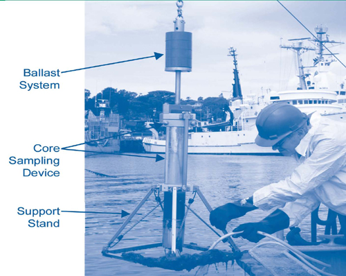
The sampler's ballast system contains a lift shaft, lift shackle, and weight spindle holding up to five 10-lb weights. Using direct pressure or pounding (raising and dropping weights over the shaft end), the core sampling device is directed to the target depth for tube penetration. A hydraulic piston then extrudes the retrieved core into a slicer block where the core is immobilized. When the block contains the desired sediment thickness ranging from 1 to 15 cm, the slicer blade is pulled horizontally to isolate the sample within the block’s upper collection chamber for subsequent processing.
Following laboratory and field tests, a modified prototype of the sampler was evaluated last summer at the U.S. Navy's Space and Naval Warfare (SPAWAR) Command Systems Center in San Diego, CA. Studies were conducted in two well-characterized sites at the mouths of Chollas and Paleta Creeks near Point Loma. Sediment at both sites contains aluminum and iron in concentrations averaging 14,877 and 20,537 mg/kg, respectively, and low levels of arsenic, chromium, copper, lead, mercury, and zinc. Individual samples were collected as close together as possible to minimize local sediment variation.
The evaluation included performance comparison against a conventional Ponar grab sampler. The USS sampler was used to sample three successive sediment layers (0-3 cm, 3-6 cm, and 6-9 cm), while the Ponar sampler was used to collect collocated samples of only the upper (0-3 cm) layer. Samples were analyzed at an offsite laboratory for total organic carbon (TOC) content, particle-size distribution, and concentrations of heavy metals.
Mean TOC concentrations in the Ponar-collected upper layer were 60,520 and 45,240 mg/kg at the Chollas and Paleta Creek sites, respectively. Mean TOC concentrations in samples collected by the USS sampler were significantly lower, at 35,780 and 28,720 mg/kg, respectively. The difference suggests that a higher mollusk-shell content in the Ponar samples, which can capture sediment below the target interval, led to inclusion of inorganic carbon upon shell dissolution. USS sampler-derived data also indicated that TOC concentrations at Paleta Creek slightly decreased with depth, to concentrations of 27,540 and 26,440 mg/kg in the 3-6 and 6-9 cm layers, respectively.
Heavy metal concentrations consistently were an average 20% higher in surface samples collected by the USS sampler than by the Ponar sampler. For example, an average lead concentration of 87 mg/kg was identified at Paleta Creek using the USS sampler, but Ponar-collected samples showed a concentration of 73 mg/kg. Differences may be attributed to unavoidable dilution of the 0-3 cm layer with the 3-6 cm layer materials in the Ponar samples. During typical Ponar sampling, the sample is placed into a steel pan where it tends to spread; from there, attempts are made to collect only the top 3 cm of sediment but mixing easily occurs.
Particle-size analysis led to similar conclusions regarding the inability of Ponar technology to isolate and collect only the surface layer of sediment. At Paleta Creek, the mean particle sizes of USS samples from the 0-3, 3-6, and 6-9 cm layers were 62, 51, and 93 µm, respectively, while the mean particle size for Ponar upper-layer samples was slightly higher, at 68 µm. ORD will issue a detailed report on this evaluation in early 2007. Results from an earlier field test of the USS sampler are available in Collection of Undisturbed Surface Sediments: Sampler Design and Initial Evaluation Testing [EPA/600/R-05/076] online at http://www.epa.gov/nerlesd1/cmb/pdf /USS_Sampler_FINAL_REPORT.pdf.
Contributed by Brian Schumacher, Ph.D., NERL (schumacher.brian@epa.gov or 702-798-2242), John Zimmerman, NERL (zimmerman.johnh@epa.gov or 702-798-2385), Julia Capri, Eastern Research Group (julia.capri@erg.com oor 513-791-9405), and V. Elliott Smith, Ph.D., ASCi Corporation (esmiths@comcast.net or 248-342-8744)
Combined Benthic Test Determines Metal and Organic Flux Rates in Marine Sediment
Contaminant flux rates from marine sediment recently were measured at Bishop Point in Pearl Harbor, HI, using the benthic flux sampling device (BFSD) developed by SPAWAR Systems Center (SSC)/San Diego. Reductions in field time and costs were achieved through simultaneous measurement of both metal and organic contaminants during 72-hour deployment of the BFSD. These measurements were compared to the results of previous Bishop Point BFSD deployments focusing on metals versus polycyclic aromatic hydrocarbons (PAHs) and on different occasions. Comparison showed very similar quantitative and qualitative results.
The tests were conducted at the Navy's Marine Diving and Salvage Unit 1 (MDSU-1) facility of Bishop Point, near the mouth of Pearl Harbor, to support ongoing cleanup of this National Priorities List site. MDSU-1 is located near active industrial and Navy operations employing numerous surface-water vessels such as salvage and dive-boats, research ships, and barges periodically moved by tugboats. Surface water in this area is generally clear and approximately 25 feet deep. Sediment comprises fine- to medium-grained sand.
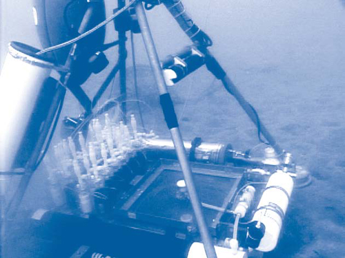
The BFSD typically is deployed from a davit-capable boat from which sampling, data logging, and control functions operate automatically according to preprogrammed parameters. A chamber within the device traps a volume of water directly above the sediment/water interface and automatically collects samples at various intervals (Figure 2). The chamber is a bottomless box, approximately 40 cm square and 18 cm tall, with a capacity of approximately 30 liters. A sensor-triggered oxygen injection system is housed in the BFSD to sustain ambient dissolved oxygen concentrations (± 1 mL/L) inside the chamber.
For the combined contaminant-type test, one ambient and 11 split samples were collected from the chamber at approximate 7-hour sampling intervals using 100-mL Teflon bottles for metals and 250-mL amber glass bottles for PAHs. Collected samples immediately passed through 40-micron glass-fiber filters within the BFSD. After the typical 72-hour deployment, sample bottles were retrieved, packaged, and sent to an offsite laboratory. Ancillary data also were collected through use of an onboard conductivity, temperature, and depth system. The BFSD was deployed at a single location over three days, but earlier applications indicate that a complete turnaround (including retrieval, decontamination, reloading, and deployment) can be accomplished in a single day.
These analytical results and ancillary measurements, as well as data from the earlier metals-only and PAH-only BFSD deployments, were incorporated into a time-series analysis that showed flux rates for metals and PAHs behaved similarly across both scenarios. Arsenic, cadmium, lead, nickel, manganese, and zinc consistently fluxed out of sediment at rates ranging from 1.3 µg/m²/day for cadmium to 1,940 µg/m²/day for manganese, while copper fluxed into sediment at a rate of 71.3 µg/m²/day. Slightly higher flux rates for metals were identified through the combined deployment than during metals-only testing.
With the exception of phenanthrene, all measured PAHs fluxed out of the sediment. The highest PAH flux rate (19,696 ng/m²/day) was for fluoranthene, followed by anthracene, acenaphthene, and naphthalene. High concentrations of heavier molecular weight PAHs such as benzo(a)pyrene, benzo(k)flouranthene, and chrysene also were identified. Benzo(a)pyrene was detected in samples collected during the combined testing but not in the early PAH-only test.
BFSD deployment using this combined method for metals and organics was estimated to save more than $10,000 and four field days when compared to the cost of two separate rounds of deployment. Applications at Bishop Point and other sediment sites indicate that the BFSD is suitable in aquatic near-shore environments at depths up to 50 meters. The device may be used effectively in coastal areas with steep sediment gradients where pore-water sampling is difficult. In addition to evaluating contaminant diffusion, as typically derived from pore-water analysis, the device helps to determine the direction and magnitude of sediment/water interface gradients.
Final results of the Bishop Point tests, which were conducted as a demonstration under the U.S. Department of Defense Environmental Security Technology Certification Program, will be available online this spring at http://www.estcp.org.
Contributed by Brad Davidson, SCC (bradley.davidson@navy.mil or 619-553-2804)
ELISA Added to Rapid Screening Characterization Toolbox
The U.S. EPA and U.S. Army Corps of Engineers, along with a team of researchers from Battelle, ENVIRON, University of Maryland-Baltimore, and the U.S. Navy, are examining the fate and transport of hydrophobic contaminants below capped sediment at the Wyckoff/Eagle Harbor Superfund Site in Bainbridge, WA. The study involves use of an in-field rapid screening characterization (RSC) tool known as enzyme-linked immunosorbent assay (ELISA). Study results show that ELISA effectively provides field measurements of target contaminants, facilitates real-time decisions regarding sample locations, and reduces the quantity of samples requiring detailed and expensive analysis at offsite laboratories.
PAH compounds are the primary contaminants of concern (COCs) at this site due to the use of creosote during past wood-preservation activities. A high potential for vertical migration of dissolved contaminants exists due to the area's 10-foot tidal fluctuations and a steep upward hydraulic gradient in the underlying aquifer. Recent field work focused on identifying and measuring in-situ hydrodynamic forces and contaminant migration in buried sediment as well as the 3-foot-thick, 13-acre cap in place since 2001.
ELISA uses antibodies and enzyme conjugates to detect and quantify COCs. In this immunoassay, an enzyme is linked chemically to a COC molecule to create a labeled COC reagent, or conjugate. The COC-antibody or enzyme-COC-antibody complex attached to a test surface reflects the sample's amount of COC. Enzyme on the test surface catalyzes a color-change reaction when solution is added to the test surface, and the amount of color inversely corresponds to the COC concentration.
The recent fate and transport study combined data from an earlier field conductivity survey with onsite and offsite chemical data from the sediment cap and native sediment. The information helped determine the potential for vertical PAH migration in the sediment cap as well as the relative influences of ground-water upwelling and tidal fluctuations on contaminant transport. Conductivity surveys located areas of potential fresh-water upwelling into the marine surface water, which in turn represented the greatest potential for upward vertical pore-water migration and indicated optimal locations for sediment/cap core collection.
Thirteen 3-inch-diameter cores were collected from the sediment cap and native sediment within and outside of ground-water upwelling areas. To examine the full sediment/cap interface, each core extended 1-3 feet beyond the cap. Cap cores were sectioned into 32 intervals above the native sediment/cap interface, and 2-4 intervals were collected from native sediment.
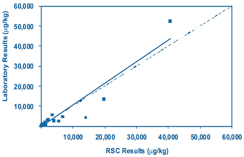
ELISA was used to measure total PAH (TPAH) concentrations in each of the selected core segments, which helped avoid costs for offsite laboratory analysis of samples with non-detects. Based on ELISA results, 26 core segments from only 4 cores were selected for offsite analysis to evaluate 34 individual PAHs, particle size distribution, and TOC. Comparison of TPAH concentrations identified from ELISA RSC and TPAH concentrations determined through laboratory gas chromatography/mass spectrometry methods showed an overall correlation coefficient of 0.9 (Figure 3). For TPAH concentrations less than 1 mg/kg, the correlation coefficient was 0.7.
As a result, RSC data were used to develop a reliable profile of TPAH concentrations within the existing sediment cap, and study costs could be further reduced by the need for less offsite laboratory analysis supporting profile development. The RSC-based profile will be integrated into ongoing cap monitoring efforts and evaluation of the cap’s performance. Final results for this project, which was funded by the Strategic Environmental Research and Development Program will be available online later this year at http://www.serdp.org.
Contributed by Marc Mills, Ph.D., U.S. EPA ORD/National Risk Management Research Laboratory (mills.marc@epa.gov or 513-569-7322), Victor Magar, Ph.D., ENVIRON (vmagar@environcorp.com or 312-731-2419), Bruce Sass, Ph.D. Battelle (sassb@battelle.org or 614-424-6315), and Jim Leather, SCC (jim.leather@navy.mil or 619-553-6240)
Integrated Pore-Water and Geophysical Investigations Streamline Characterization of Ground-Water Discharges to Surface Water
The Michigan Department of Environmental Quality (MDEQ) uses a site characterization approach relying on optimal use of sediment pore-water data to delineate contaminant ground-water plumes entering surface water bodies. The approach combines plume delineation data obtained through simple, miniature piezometer-based pore-water sampling with subsequent information collected through conventional wells and advanced geophysical techniques. This stepwise process helps to define both horizontal and vertical preferential flow pathways, and subsequently to install additional permanent wells for monitoring the ground-water/surface-water interface at critical locations and depths.
The approach was used last year to investigate soil and ground-water contamination at the site of Hoskins Manufacturing, a former wire-manufacturing facility in northeast Michigan. Over more than 30 years, operations waste containing tetrachloroethene (PCE), hexavalent chromium (Cr+6), and spent pickling brine had been released into an unlined lagoon and smaller source areas. Resulting seepage contaminated sandy vadose soil extending to the water table and contaminated a drinking-water aquifer prior to its discharge into a nearby cold-water creek, which ultimately drains into Lake Huron.
Pushpoint pore-water tools were used to conduct preliminary sampling beneath the creek bottom in areas intersecting the apparent plume. Once the horizontal extent of the plume was determined, pushpoint sampling continued over a two-day, high-density effort to collect samples from alluvial sediment along the creek and throughout the floodplain in the vicinity of the discharge, thus delineating the area of plume expression. During sampling, field measurement of water quality parameters (pH, conductivity, dissolved oxygen, temperature, and oxidation/reduction potential) provided useful geochemical information throughout the contaminant discharge area. Pore-water tools also were used to measure associated hydraulic potential (potentiometric surface elevation) at the sample locations, and to help determine the thickness of local vegetative mat and the extent of a sand/gravel substrate underlying the study area.
Analytical results from an MDEQ mobile laboratory indicated that some of the plume's highest PCE and Cr+6 concentrations were found in the pore-water samples. Offsite laboratory analysis confirmed that the highest pore-water PCE concentration (approximately 500 µg/L) and Cr+6 concentration (7,360 µg/L) in valley sediments were slightly higher than concentrations in ground water collected from deep upgradient monitoring wells. These trends indicated that very little attenuation of contaminants is occurring during plume migration. Correlations in pore-water concentrations of chromium and chloride also confirmed earlier indications that Cr+6 travels with the brine.
Overall results indicate that PCE, present mainly in the upper part of the shallow aquifer, primarily discharges directly into the creek bottom or through the vegetative mat prior to entering the creek. Cr+6 and brine in the lower part of the shallow aquifer, however, tend to discharge through the creek bed or through the vegetative mat on the creek’s far side. Prior to investigation, potential for contaminant discharge through the vegetative mat was considered minimal due to the mat's anticipated low hydraulic conductivity.
Of the field parameters measured, specific conductivity provided the best indication of plume discharge. Increased electrical conductance due to the brine provided an easily recognizable marker of Cr+6 in the floodplain. Areas of lowest temperature generally contained the highest Cr+6 and PCE concentrations, suggesting that temperature may serve as an additional indicator of ground-water discharge. Data suggest that a discharge of about 5 L/s of highly contaminated ground water mixes with the creek water, resulting in low but measurable concentrations of these contaminants in the creek flow.
Once the plume discharge was defined, several geophysical techniques were used to characterize the aquifer and identify preferential ground-water flow pathways before installing additional deep monitoring wells. These methods included "SuperSting" resistivity/induced polarization, seismic reflection, and downhole gamma-ray and electromagnetic-induction logging techniques. Vertical aquifer sampling was used in concert with sonic drilling to determine the optimum well screen elevations, and continuous coring during this process allowed visual examination of the aquifer material. Resulting geological profiles indicated a complex, 500-foot-thick glacial layer of fine to coarse sand with interbedded silt and clay lenses. Using these profiles, six 400-foot monitoring wells were installed parallel to the 0.7-mile route of plume migration from the facility.
MDEQ estimates that costs for the entire pore-water investigation totaled less than $15,000. Although the project findings determined that the plume discharges to the creek and alluvial valley sediment, additional spatial and vertical delineation of glacial sediment is required to fully delineate the upgradient portion of the plume before remediation planning begins. Access to the valley bottom with conventional equipment is difficult. Consequently, plume movement and stability will be monitored through the use of permanent miniature wells to be installed at shallow depths in the floodplain discharge area. A macroinvertebrate investigation also will be conducted this year to evaluate contaminant impacts on the aquatic community.
Contributed by Mark Henry, MDEQ, (henryma@michigan.gov or 517-335-3390)
