![]() A newsletter about soil, sediment, and groundwater characterization and remediation technologies
A newsletter about soil, sediment, and groundwater characterization and remediation technologies
This issue of Technology News and Trends highlights techniques to enhance site investigations through advanced data integration and high resolution technology such as membrane interface probes, electrical resistivity imagery, and compound specific isotope analysis. In addition to improving the conceptual site model, use of these field and laboratory tools can aid in the selection of innovative design, construction, and monitoring approaches facilitating increased use of in situ cleanup remedies.
Revised Characterization Plan Accelerates Petroleum Brownfield Cleanup and Redevelopment
CLU-IN Resources
Extensive information about contaminated site characterization and monitoring is available on the U.S. Environmental Protection Agency’s (EPA’s) CLU-IN web host. Topics currently include typical uses, components, operational modes, performance specifications, and verification reports on 20 analytical, direct-push, and geophysical tools. Learn more at: www.cluin.org/characterization/.
Efforts to better delineate contamination and accelerate remediation of the former Fannon Petroleum Services site in Alexandria, VA, were initiated in the early 2000s as part of a plan to redevelop the site for residential use. Strategically located near the Potomac River in "Old Town" Alexandria, the site had been used as a fuel depot since the 1880s. Discovery of up to 40 inches of petroleum product in monitoring wells near the site in the early 1980s prompted a preliminary site investigation and recovery of oil. Continued high concentrations of dissolved contaminants, slow rates of oil recovery, and the property's high potential for redevelopment collectively prompted an effort to better define the nature and extent of contamination, identify all areas needing remediation, and characterize the risk associated with remaining contamination. Project success is attributed to combined efforts of the property owner, the Virginia Department of Environmental Quality (VA DEQ), and the City to address the site's environmental and economic issues.
Historical records suggest that 50,000 gallons of fuel could have been released since 1962 due to poor procedures for handling and storing materials such as gasoline, diesel, kerosene, ethanol, and methanol. When the petroleum product was discovered by utility maintenance crews working at neighboring properties in 1982, the high volume of fuel suggested that the utility work had ruptured an underground fuel line. After several years of oil recovery by the site owner, groundwater monitoring in the early 1990s identified a free-phase plume extending from the underground storage tank (UST) and loading rack area. By the late 1990s, monitoring indicated that the contaminant plume had migrated to offsite properties as far as 300 feet from the suspected source area. An onsite groundwater pump-and-treat (P&T) system and soil vapor extraction system began operating in 2001 to treat subsurface areas targeted through investigations relying on conventional sampling techniques. Groundwater was extracted for treatment at a rate of approximately 6 gal/hr.
As part of the plan for improved site characterization and accelerated cleanup, the VA DEQ initiated the Triad approach. Project planning included development of a conceptual site model and consensus on specific investigative methods and tools, with a focus on using: (1) a membrane interface probe (MIP) to characterize distribution of volatile organic compounds (VOCs) in discrete hydrologic units and soil stratigraphy at offsite locations; (2) direct-sensing geophysical tools rather than groundwater and soil sampling for initial screening; and (3) a dynamic work strategy to allow real-time decision making that could identify specific locations for direct-sensing locations as work proceeded. Onsite areas of contaminated material were delineated for excavation and offsite disposal during the anticipated residential construction.
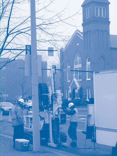
In early 2006, MIP data mapping began on the properties and streets adjacent to and downgradient of the fuel depot. The use of MIP technology at Fannon involved a portable controller and a direct-push rig to advance a probe into the subsurface for the purpose of heating the soil, water, and vapor matrix. The heated VOCs were drawn across a permeable membrane near the tip of the probe and carried by an inert purge gas through small-diameter tubing connected to a sensor detection system at ground surface. The detection system consisted of three direct-sensing tools: a photoionization detector (PID), a flame ionization detector (FID), and an electron capture detector. Along with a portable gas chromatograph for periodic confirmatory analysis, these detectors helped delineate subsurface zones of petroleum product and specific types of VOCs. All detection, analytical, and control equipment was transported in a standard utility vehicle traveling a few feet in front of the direct-push rig (Figure 1).
An average of five probes were advanced daily, each resulting in a continuous, vertical 30- to 40-foot profile of the subsurface with more than 20 data points per foot. Chemical and geological data from each profile included VOC concentrations identified through PID and FID, soil conductivity, and temperature measurements. Electronic displays of the profiles and associated three-dimensional (3-D) maps were viewed in the field by the VA DEQ, the site owner's environmental consultant, City staff, and other stakeholders for better-informed and faster decisions. MIP data were collected through a total of 44 probes during a single mobilization spanning two weeks. The survey was terminated once the VA DEQ and environmental consultant agreed on the extent and severity of the offsite plume.
The MIP results generally correlated with the plume defined by earlier, conventional methods but identified a previously unknown offsite lobe of contamination. Conceptual model refinement indicated a 60- by 120-foot plume at a depth of 15 feet below ground surface (bgs). High resolution mapping of the lobe suggested that the free-phase plume intersected and then migrated along the municipal sanitary/storm sewer system. This area of contamination, which years of conventional investigation had failed to identify, accounted for the significant offsite contamination discovered during the 1982 utility work. Overall results indicated that removal of the source area during residential construction should prevent further plume migration. MIP mapping also led to identification of an alternate location for the remedial system on a downgradient adjacent property.
Twenty-eight USTs, underground piping, the terminal loading rack, and approximately 35,000 tons of petroleum-contaminated soil subsequently were excavated and removed from the source area. The remedial system was concurrently transferred to its new location, and several new extraction wells were installed to supplement existing offsite recovery wells.
Costs for MIP deployment and onsite detection and analysis equipment for several weeks of field work totaled approximately $55,000. In contrast, earlier site characterizations through conventional methods in conjunction with many soil and groundwater sample analyses had cost hundreds of thousands of dollars and numerous mobilizations over multiple years.
Conventional sample analysis now indicates that the P&T system is hydraulically controlling the contaminant plume and reducing the remaining free-phase fuel oil and dissolved-phase groundwater contaminants. The system will continue operating until the VA DEQ-approved risk-based cleanup goals are met.
More About Accelerating Urban Brownfield Cleanup
EPA partnered with the New York City Office of Environmental Remediation to compile the report, Streamlining Site Cleanup in New York City (EPA 542-R-10-005). The report presents a plan for using the Triad approach and associated best practives to characterize sites and optimize remediation of low to moderately contaminated land while addressing a municipal need to sustainably develop commercial, residential, and recreational properties. Use of Triad in the New York metropolitan area has shown significant advantages for brownfields redevelopment programs, including those involving old fill areas and waterfront property. Access the report from EPA's Brownfields and Land Revitalization Technology Support Center at: www.brownfieldstsc.org/.
To date, the P&T systems have treated over 6 million gallons of petroleum-contaminated groundwater and removed over 4,200 pounds of total petroleum hydrocarbons, 350 pounds of benzene, toluene, ethene, and xylenes (BTEX), 78 pounds of methyl-tertiary-butyl ether (MTBE), and 15 pounds of naphthalene. An estimated 5,000 gallons of fuel oil have been recovered, and nearly 7,000 pounds of subsurface petroleum vapors have been removed.
Remedial actions specified in the redevelopment plans (per the city's contaminated land program) included a vapor intrusion abatement system comprising an upgraded vapor barrier, active sub-slab ventilation, and a treatment unit for groundwater drainage to eliminate any potential risks of exposure from the development. Use of MIP also enabled stakeholders to revise the site's construction plan to include a depth restriction for anticipated structures. Residential construction began in 2008 and was completed in 2010.
Contributed by Randy Chapman, VA DEQ (randy.chapman@deq.virginia.gov or 703-583-3816) and Daniel Imig, City of Alexandria Office of Environmental Quality (daniel.imig@alexandriava.gov or 703-746-4070)
ERI Survey Helps Delineate TCE Plume and Guide Field Testing of Innovative ISCO Candle Technology
A 1989 investigation by the Nebraska Department of Environmental Quality (NDEQ) found a high concentration (37,000 µg/L) of trichloroethene (TCE) and other VOCs in shallow groundwater near a closed cell of a former municipal landfill in Cozad, NE. Using funds from an NDEQ landfill closure grant, the City conducted numerous site investigations and installed several remedial measures. By 2008, however, annual groundwater monitoring indicated that the average TCE concentration in groundwater remained elevated at 688 ug/L. With NDEQ's and the City's concurrence, the University of Nebraska-Lincoln (UNL) began an effort in 2009 to investigate new tools for subsurface characterization and field test an alternative remedial technology. Project funding was provided to UNL by the U.S. Congress and administered by EPA through a cooperative agreement.
The City of Cozad had owned and operated the landfill until 1987, when the facility was closed due to noncompliance with the State's new regulations on small municipal landfills. The site's unlined 400- by 40-foot waste cell extends 20 feet bgs and is capped with a thin layer of clay soil. Approximately 5 feet of silty clay separates the bottom of the cell from 35 feet of alluvial sand, which overlies the Ogallala member of the High Plains Aquifer. The City's early site investigation included installing 19 groundwater monitoring wells to depths of 8-170 feet bgs. As of 2008, groundwater modeling estimated a VOC plume about 600 feet long, 125 feet wide, and 20 feet deep. Limited success of the remedial attempts, which included a dual-phase extraction well system, poplar trees to induce phytoremediation, and several volatilization ponds, was attributed to low permeability of the aquifer and insufficient characterization of the contaminant plume.
The subsequent UNL investigation used electrical resistivity imaging (ERI) to characterize the closed cell area. Grid and boundary lines of the survey were based on historical TCE groundwater concentrations, proximity of the highest TCE concentrations to a targeted (east) portion of the cell, existing poplars and evaporation ponds, and property lines representing legal points of compliance. Over three days in September 2009, images at more than 7,100 data points were collected along 22 survey lines.
ERI results identified three distinct conductivity layers in the substrata, which corresponded to differences in lithology and hydraulic conductivities. The ERI maps were used to guide groundwater sampling via direct push technology. Soil and groundwater samples were collected from depths of 5-69 feet bgs at 64 locations. Results of this focused sampling effort indicated that the vast majority of contamination was contained in a layer of low-permeability loess near the water table, within 20 feet of the ground surface. Not all of the loess was found to be contaminated, but essentially all of the contamination was located in this low permeability layer.
With technical assistance from UNL, the ERI survey was performed in part by Oklahoma State University faculty at a discounted research-based cost of $9,000. Costs for groundwater sample collection and analysis (completed primarily by UNL graduate students) totaled approximately $17,000. When compared to commercial projects, NDEQ estimates a significant savings in field and analytical labor expenses attributable to the project's academic partners.
Improved understanding of the site's remedial progress and current extent of contamination enabled project partners to explore lower-cost remedial technologies, particularly in situ chemical oxidation (ISCO). Conventional ISCO by injecting liquid oxidants into groundwater was anticipated to be unsuccessful, due to the low aquifer conductivity within the target area. Instead, slow-release potassium permanganate candles (SRPCs) were selected for use on a pilot-scale basis. SRPCs consist of granular potassium permanganate (KMnO4) embedded in a paraffin wax matrix. Earlier laboratory SRPC studies by Ohio State University demonstrated that the KMnO4 slowly dissolves and diffuses through the wax matrix upon contact with water. The MnO4- can then react with chlorinated solvents such as TCE and reduce them to CO2 and Cl-.
UNL researchers developed an in-house SRPC production process, conducted bench-scale tests to quantify the SRPC dissolution rates, and designed an SRPC system to be applied at the landfill. Treatability study results (using core samples collected from the site) indicated KMnO4 breakthrough across 1.74 cm of soil occurred within 24 hours for most samples. Laboratory performance of miniature SRPCs predicted a lifespan of 7.5 and 16.5 years, respectively, for two- and three-inch-diameter SRPCs, based on a predicted MNO4 release rate of 3 grams/day in each treatment well. Additional trials at UNL included testing the potential explosion hazard of a full-scale 3-inch candle. Failure to explode during cap blasting supported earlier laboratory findings that the presence of paraffin wax avoids the explosion risk posed by dry permanganate.
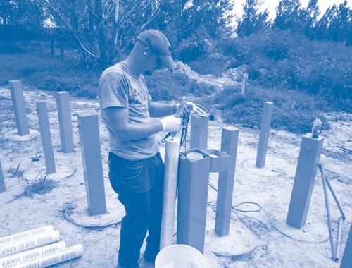
With technical oversight from NDEQ, a total of 50 three-inch and 105 two-inch SRPCs were installed in July 2010; each SRPC was three feet long. The three-inch SRPCs were inserted into tailored containers and placed inside 4-inch-diameter wells installed using direct push technology on 4-foot centers to a depth of 22 feet (Figure 2). The two-inch SRPCs were placed directly into the aquifer at 5-foot increments through use of hollow direct-push rods (on 2-foot centers) reaching 22 feet bgs. Collectively, the candles contained approximately 1,400 pounds of KMnO4 and 300 pounds of paraffin. Upon oxidant diffusion, the emplaced materials would essentially create a 20-foot-wide permeable reactive barrier intersecting the plume portion with highest TCE concentrations.
Groundwater sampling conducted 85 days after SRPC installation indicated an 80-85% reduction of total VOC concentrations in treatment zone monitoring wells. Sampling results from one shallow well within the treatment zone, for example, exhibited a TCE concentration approaching 400 µg/L prior to SRPC installation and a post-treatment TCE concentration of approximately 75 µg/L. Detection of MnO4- in a deeper well indicated diffusion of the slow-releasing oxidant had started to occur, which supported prediction that uniform KMnO4 distribution throughout the target subsurface area could occur in 6-12 months after installation. Currently, the TCE concentration in the downgradient point of compliance well is slightly below the 5 µg/L federal maximum contaminant level (MCL), and groundwater sampling shows no evidence of impacts on the deeper Ogallala Aquifer.
Pilot study costs for the SRPC installation total approximately $18,000 to date; this includes $4,000 for chemicals and $14,000 for installing the monitoring wells and SRPC wells and renting direct push equipment. Pending SRPC efficacy in meeting the State's groundwater protection standard for TCE (below 5 µg/L), NDEQ anticipates the City will oversee the SRPC system after UNL work is complete. Future evaluation of whether changes can be made to the existing remediation systems also is anticipated, to reduce operation and maintenance costs while still meeting the cleanup goals within 20 years.
Contributed by Steve Comfort, Ph.D., and Mark Christenson, UNL (scomfort@unl.edu or 402-472-1502), Laurie Brunner, NDEQ (laurie.brunner@nebraska.gov or 402-471-2214), and Kenneth Rapplean, EPA Region 7 (rapplean.kenneth@epa.gov or 913-551-7769)
3D-CSIA Forensics at the FAMU Law School Site Reveals Multiple Contaminant Sources
The Florida Department of Environmental Protection (FL DEP) recently conducted a 3-D compound-specific isotope analysis (3D-CSIA) investigation at the Florida Agricultural and Mechanical University (FAMU) Law School site in downtown Orlando. This 3D-CSIA was undertaken as part of a multiple lines of evidence approach to determine potential sources of groundwater contamination. Previous FAMU-sponsored groundwater investigations identified widespread chlorinated hydrocarbons at concentrations exceeding Florida Primary Drinking Water Standards (FPDWS). To better understand potential sources of these contaminants, the FL DEP examined isotope ratios of the three elements (13C/12C, 37Cl/35Cl, and 2H/1H) in the primary contaminants of concern, tetrachloroethene (PCE), TCE, and cis-1,2-dichloroethene (cDCE).
Since the isotopic ratios of PCE and TCE vary depending on the manufacturer, 3D-CSIA can be used to help differentiate sources of the chlorinated solvents and determine the sequence of multiple releases based on a site's past PCE, TCE, and cDCE usage. The technique also can help identify, characterize, and quantify biotic and abiotic transformation reactions because both biotic and abiotic degradation processes are associated with significant isotopic fractionation. Results of isotope analyses are generally reported as δ values, e.g., δ13C for carbon, δ37Cl for chlorine, and δ2H for hydrogen. The δ symbol represents a comparison between the ratios of the different stable isotopes of an element, such as 13C to 12C, 37Cl to 35Cl, and 2H to 1H, and is expressed in parts per thousand (‰) of an internationally accepted standard reference concentration. A δ13C of -30‰, for example, indicates that the ratio of 13C to 12C in the sample is 3% lower than the standard. A more negative δ value indicates that a chemical is depleted in the heavier isotope (13C, 37Cl, or 2H). Biodegradation agents preferentially break down the lighter isotopes of different elements, inducing a shift of the residual compound to a less negative δ13C value. A more negative δ13C value would suggest a closer source and more recent release of a chemical into the environment.
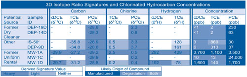
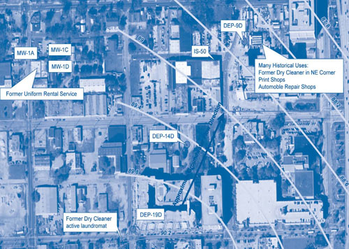
The target investigation area at the FAMU Law School encompasses approximately eight city blocks that include various businesses and residential complexes. The site is underlain by about 50 feet of fine- to medium-grain sand with increasing silt and clay with depth. The average depth to the water table is 11 feet bgs. Nearly all deep groundwater samples collected at the site were found to contain detectable levels of chlorinated hydrocarbons, with many exceeding FPDWS. The highest PCE, TCE, and cDCE concentrations (Table 1) were detected in three monitoring wells located near a former uniform rental service in the northwestern corner of the study area (Figure 3). Based on past and current property uses, other potential sources of PCE, TCE, and cDCE in the target area include former dry cleaners, print shops, and automobile repair shops.
During the winter of 2009, groundwater samples from seven wells at the FAMU site were analyzed for both the presence of chlorinated VOCs and their isotope ratios. A gas chromatograph coupled with an isotope-ratio mass spectrometer was used to determine the isotope ratios for chlorinated VOCs detected at concentrations greater than 10 parts per billion (ppb).
Techniques for collecting and preserving groundwater samples for 3D-CSIA are identical to those for VOC analysis using EPA Method 8620B. In this investigation, all samples were collected using standardized techniques and then shipped to an offsite laboratory. The average cost for each set of 3D isotopic signatures of cDCE, TCE, and PCE was $900.
The highest concentrations of PCE (1,700-24,000 ppb) were detected in the three wells near the former uniform rental service (Table 1). The PCE in the wells have similar δ13C and δ37Cl ratios, indicating a major release of PCE from a single source. The δ13C measured in TCE at MW-1A is indicative of a manufactured TCE; the significantly different δ37Cl and the very high δ2H also support a manufactured source of TCE in this well. However, the ratios measured for TCE in MW-1D indicate some biodegradation of PCE is occurring. The lighter δ13C, similar δ37Cl, and low δ2H suggest biodegradation. The cDCE in both wells appears to have a manufactured origin.
Wells IS-50’ and DEP-9D are located even further downgradient of the former dry cleaner, but have higher concentrations of TCE than PCE. The δ13C and δ37Cl ratios for PCE in these wells are heavier than for TCE, suggesting TCE is primarily a product biotic transformation. However, the 128‰ δ2H in IS-50’ indicates the manufactured TCE may be commingled with a small amount of TCE that has degraded from PCE.
Wells DEP-19D and DEP-14D, located downgradient of a former dry cleaner at the south edge of the site, had similar δ13C ratios for PCE but slightly different δ37Cl ratios. Both matched ratios for manufactured PCE, potentially indicating the potential use and release of different PCE formulations at the former dry cleaner (Table 1).
New Technical Bulletin
EPA's Office of Solid Waste and Emergency Response recently issued Best Management Practices: Use of Systematic Project Planning Under a Triad Approach for Site Assessment and Cleanup (EPA 542-F-10-010). Topics include use of a conceptual site model and samples of successful systematic project planning. Access the bulletin at:http://www.brownfieldstsc.org/.
Costs for 3D-CSIA planning, laboratory analysis, and data interpretation at the FAMU site totaled approximately $9,500. Using this approach, the FL DEP was able to confirm two hydrocarbon release sources, as indicated by earlier groundwater sampling, at the FAMU site. Overall 3D-CSIA results indicate that the former dry cleaner and former uniform rental service were the main contributors to groundwater contamination. Isotopic data from wells IS-50’ and DEP-9D, however, suggest other as of yet unidentified sources of chlorinated hydrocarbons. The FL DEP is planning remediation of the site as efforts to delineate other contaminant sources continues, and anticipates using results of this study as background information for future FL DEP investigations.
Contributed by Jeff Newton, Florida DEP (Jeff.Newton@dep.state.fl.us or 850-245-8955), Amber Igoe, TetraTech (Amber.Igoe@tetratech.com or 850-385-9866), and Yi Wang, Ph.D., DPRA-ZymaX Forensics Isotope Laboratory (Yi.Wang@zymaxusa.com or 760-781-3338 ext. 43)
