![]() A newsletter about soil, sediment, and groundwater characterization and remediation technologies
A newsletter about soil, sediment, and groundwater characterization and remediation technologies
- Use of Triad Cuts Disposal Cost in Half at Wenatchee, WA, Pesticide Site
- Triad Strategy Focuses Course of Vint Hill BRAC Site Characterization
- Key Triad References
- Triad Used for Targeted Brownfields Assessment of Former Cos Cob Power Plant
- Municipality Applies Triad to Accelerate Brownfields Redevelopment at Assunpink Creek Site
- Dynamic Site Characterization Used for Fort Lewis DNAPL Contamination
- EPA and USACE Assist East Palo Alto Residents with Pesticide Issues
- McGuire Air Force Base Completes Rapid Characterization at MILCON Project
- Triad Workshops, Training, and Conference Sessions
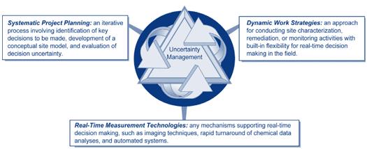
Along with other Federal Agencies, the USEPA is promoting the use of an integrated strategy for limiting decision uncertainty at hazardous wastes. This major initiative, called Triad, uses systematic planning, dynamic work strategies, and real-time measurement technologies that include field-based analyses. Recently, Triad practitioners have emphasized use of multidisciplinary project teams and decision support tools such as FIELDS, SADA, and Scribe.
This issue of Technology News and Trends focuses on recent Triad applications employed by federal, state, and local agencies to minimize uncertainty while expediting site cleanup and reducing project costs. Applications with realized cost savings are highlighted.
Use of Triad Cuts Disposal Cost in Half at Wenatchee, WA, Pesticide Site
Triad Internet Resources
The U.S. EPA’s Technology Innovation Program (TIP) provides quick access to guidance documents, site-specific application summaries, and training on the Triad initiative through the CLU-IN web site at http://www.cluin.org/triad. EPA also has partnered with other federal and state agencies to develop the Triad Resource Center web site (https://triadcentral.clu-in.org) as the one-stop shop for, case studies, technical information, regulatory perspective, and guidance. As another interagency effort, the Brownfields technical Support Center provides Triad support to EPA regions, states, localities, and tribes involved in brownfields redevelopment (http://www.brownfieldstsc.org).
The U.S. Army Corps of Engineers (USACE) first applied Triad during the late 1990s to expedite cleanup of a test plot located at the Wenatchee Tree Fruit Research and Extension Center (WTFREC) in Wenatchee, WA. The approach allowed for characterization, excavation, and segregation of pesticide-contaminated soil based on the results of rapid onsite analyses using commercially available immunoassay kits. Joint efforts in systematic planning from the onset on the part of the USACE, EPA, site owners, and state regulators significantly contributed to the success of Triad at WTFREC.
Development of a conceptual site model (CSM) based on site-specific historical records was the first step in integrating site characterization and remediation at the 2,100-ft2 test plot. Prior to full-scale application of the Triad approach, a pilot test was conducted to assess the suitability of using onsite immunoassays and traditional fixed laboratory methods. Pilot test results demonstrated the applicability of DDT and cyclodiene immunoassays and helped to develop site-specific action levels. The project team determined that negative results using the EnviroGard® DDT immunoassay kit indicated the target cleanup level of 5 mg/kg had been met for individual compounds such as DDT, DDE, and DDD. Using the RaPID Assay® cyclodienes immunoassay kit, a cleanup level of 0.086 mg/kg was established for compounds such as dieldrin, aldrin, and endrin. These levels were refined during the project as additional data sets from both the immunoassay and fixed-laboratory analyses became available.
Following the pilot test, a soil excavation profile was developed in the field using analytical results according to a decision matrix developed by the USACE. Several phases of field activities were conducted under a dynamic workplan (DWP) that allowed for real-time decision making in the field. The preliminary CSM assumed that soil contamination existed only within the site’s fenced boundaries, but immunoassay results obtained in the field indicated otherwise. The workplan’s dynamic nature permitted the field team to expand characterization and excavation beyond the site boundaries for addressing the “surprise” contaminants without incurring a second mobilization.
A total of 271 samples were analyzed for focused removal, characterization, confirmation, waste profiling, and wastewater analysis. Approximately two-thirds of the analyses were performed in the field using immunoassays.
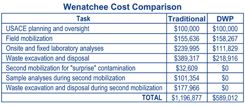
Complete characterization and cleanup of the WTFREC were accomplished within a single four-month field mobilization. The project cost was estimated to be 50% ($500K) lower than that expected with a traditional scenario (Figure 1) relying on multiple rounds of mobilization, sampling, sample shipment, laboratory analysis, and data assessment. Waste disposal costs were reduced significantly through the use of field analyses to characterize and segregate wastes that require costly incineration from those suitable for less expensive disposal methods.
Details about this project are described in the publication Innovations in Site Characterization Case Study: Site Cleanup of the Wenatchee Tree Fruit Test Plot Site Using a Dynamic Work Plan (EPA 542-R-00-009), available at http://www.clu-in.org.
For more information, contact Kira Lynch, USACE, at 206-764-6918 or kira.p.lynch@nws02.usace.army.mil.
Triad Strategy Focuses Course of Vint Hill BRAC Site Characterization
After spending $500K and three years of characterizing a BRAC (base realignment and closure) site in Fauquier County, VA, the Army began implementing Triad last summer in order to expedite the effort. A portion of the site known as Vint Hill Farms was found to contain tetrachloroethene (PCE)-contaminated soil and ground water as a result of past use of a photo-neutralization pit. The source and extent of PCE contamination, however, had not been defined prior to transfer of the property (a brownfield) to the public sector. Use of the Triad approach contributed to a complete cleanup by February 2004.
Volatile organic compounds (VOCs) were discovered in saturated soil and ground water in the overburden during RCRA closure of the neutralization pit. The Virginia Department of Environmental Quality requested rapid site characterization to determine whether VOCs had reached an onsite drinking water well located approximately 400 feet downgradient of a suspected contaminant source.
A multidisciplinary technical and regulatory team was formed to review the CSM for potential data gaps and to prepare detailed systematic plans. Using existing information, the team developed a field decision logic to identify the highest concentration of VOCs in the overburden soil and ground water upgradient of the neutralization pit. Following one week of field work, analytical results were disseminated to the team via a project-designated web site and 3-D data visualization software. Non-field personnel were brought in to the real-time, field-based decision making process through teleconferences held twice weekly.
A membrane interface probe (MIP) with electron capture detection (ECD) capability and a direct sampling ion trap mass spectrometer (DSITMS) was used to field test soil and ground water for VOCs. Each round of test results directed the location of subsequent field tests. Collaborative samples to be used in an updated risk assessment were sent to a fixed laboratory for gas chromatography/mass spectroscopy (GC/MS) analysis (Figure 2).

The full characterization project (including planning) at Vint Hill Farms was accomplished with Triad in eight months at a cost of $260K. The project team estimates that use of a traditional, stepwise approach to site characterization may have taken several years and cost over $500K.
For more information, contact Kira Lynch, USACE, at 206-764-6918 or kira.p.lynch@nws02.usace.army.mil.
More information about Triad and field-based characterization tools is available from the following guidance, technical publications, and computer-based resources developed by various organizations —and all are offered online, at no cost:
General References
- Technical and Regulatory Guidance for the Triad Approach: A New Paradigm for Environmental Project Management, ITRC, http://www.itrcweb.org/Documents/SCM-1.pdf
- Using Dynamic Field Activities for On-Site Decision Making: A Guide for Project Managers, EPA/OSWER, http://www.epa.gov/superfund/programs/dfa/guidoc.htm
- Field Analytic Technologies Encyclopedia (FATE), EPA and USACE, http://fate.cluin.org
- Several Triad "Internet Seminars" archived on EPA/TIP’s CLU-IN, http://cluin.org/studio/seminar.cfm
- USACE "Engineer Manuals" (EMs), http://140.194.76.129/publications/eng-manuals/
- Conceptual Site Models for Ordnance and Explosives and Hazardous, Toxic, and Radioactive Waste Projects (EM 1110-1-1200)
- Technical Project Planning Process (EM 200-1-2)
Published Articles
- "Managing Uncertainty in Environmental Decisions," Environmental Science & Technology, http://cluin.org/download/char/oct01est.pdf
- "In Search of Representativeness: Evolving the Environmental Data Quality Model," Quality Assurance, http://cluin.org/download/char/dataquality/dcrumbling.pdf
- "Improving Decision Quality: Making the Case for Adopting Next-Generation Site Characterization Practices," Remediation, http://cluin.org/download/char/spring2003v13n2p91.pdf
Decision Support and Data Management Tools
- Spatial Analysis and Decision Assistance (SADA) geostatistical-based decision assistance software, EPA and NRC, http://www.tiem.utk.edu/~sada/
- Scribe software tool for managing environmental data, EPA/ERT, http://www.ertsupport.org/scribe_home.htm
- Fully-Integrated Environmental Location Decision Support (FIELDS) GIS/GPS-based decision assistance software, EPA/Region 5, http://www.epa.gov/region5fields/htm/software.htm
Triad Used for Targeted Brownfields Assessment of Former Cos Cob Power Plant
The U.S. EPA collaborated with the Town of Greenwich, CT, in implementing Triad to characterize a former power plant site scheduled for redevelopment as a waterfront park. Historical records and past disposal of coal ash at the site, known as the Cos Cob Power Plant, raised concern that surface soil likely contained elevated concentrations of contaminants such as petroleum, polychlorinated biphenyls (PCBs), and asbestos. Triad was employed to obtain sufficient data during a single field mobilization to determine the nature and extent of surface soil contamination.
The preliminary CSM suggested that potential threats were limited to those posed by direct contact with contaminated surface soil and sediment. A DWP was developed to allow for expanded sampling and analytical coverage after a limited number of samples were analyzed by an offsite fixed laboratory. In accordance with Triad, the project team developed a decision tree unique to the Cos Cob site (Figure 3).

Field analytical techniques included Site Lab® ultraviolet fluorescence test kits for total petroleum hydrocarbons (TPH) and total polyaromatic hydrocarbons (PAHs). EPA’s x-ray fluorescence spectrometer was used in the field for metal detection, and GC/ECD equipment housed in EPA’s mobile laboratory was used to determine PCB concentrations and to further guide the investigation. An offsite fixed laboratory analyzed samples for arsenic on a 48-hour turnaround basis using trace inductively coupled plasma atomic emission spectrometry. The fixed laboratory also confirmed field-based identification of PCB-contaminated samples.
Based on the initial field analyses, sampling locations and depths were added or refined, and the entire field effort was completed within one week. Correlation of TPH/PAH test kit results with offsite laboratory analyses enabled the test kit results to define the extent of TPH/PAH contamination in soil. Investigation results confirmed that surface soil contains arsenic, TPH, and PAHs at concentrations exceeding the State’s residential direct exposure criteria.
Data indicated that the elevated contaminant levels resulted from coal ash co-mingling with PCB-contaminated soil in an area where transformers had been situated. Information gained through site characterization is allowing the Town of Greenwich to work further with the State and EPA to evaluate remediation options, which include placement of a soil cap on PCB hotspots.
The Triad approach yielded an estimated cost savings of 50-60% when compared with a traditional approach involving two mobilizations and comprehensive analytical methods at a fixed laboratory. Details on this application will be available this summer from the Brownfields Technology Support Center in the report entitled Innovations in Site Characterization Case Study: Expedited Site Characterization Using the Triad Approach at Cos Cob Power Plant Site, Greenwich, Connecticut.
For more information, contact Kathy Yager, U.S. EPA, at 617-918-8362 or yager.kathleen@epa.gov.
Municipality Applies Triad to Accelerate Brownfields Redevelopment at Assunpink Creek Site
The City of Trenton, NJ, began implementing the Triad approach in 2001 as part of its program to redevelop a large number of abandoned industrial sites, including conversion to recreational use of 60 acres comprising 11 land parcels along Assunpink Creek. The extent of contamination was unknown at the start of redevelopment, but preliminary assessment indicated potential presence of heavy metals, petroleum hydrocarbons, PAHs, and PCBs. It also identified a need to differentiate the impacts on specific sites from fill materials historically used throughout the area.
Through systematic planning that involved multiple stakeholder meetings, the project team assembled a preliminary CSM and an investigation approach involving two phases. Phase I addressed the nature and distribution of fill materials and specific chemicals/areas of concern requiring further investigation. This phase also included a method applicability study to demonstrate that proposed field-based methods could produce data effective for decision making.
Based on the findings from Phase I, the team developed a DWP for a Phase II investigation of particular areas of concern. The workplan addressed tools for enhancing real-time decision making in the field, including:
- A CSM, decision rules, cleanup levels, and potential field scenarios that could drive further data collection;
- Analytical procedures including Geoprobe® soil and ground-water sampling with continuous soil conductivity measurement, field-based GC/MS for PAHs, immunoassay test kits for PCBs and TPH, and x-ray fluorescence methods for metals;
- Data management and communication criteria for field documentation and communication protocols; and
- Schedules and logistics.
The dynamic work strategy relied on a three-tiered analytical program of collaborative methods: (1) field-based methods for classes of chemicals of concern with high sample throughput (immunoassays); (2) field-based methods with higher specificity (modified Method 8270 in a mobile lab); and (3) offsite, state-certified fixed laboratory methods for specific chemicals of concern to meet state regulatory requirements.
Phase II investigation activities for areas of concern along Assunpink Creek were completed within one month. Overall, the Triad approach eliminated costs associated with follow-on investigation activities while accelerating the redevelopment schedule and reducing decision uncertainty. The project team found that the approach produced robust data sets supporting stakeholder consensus in redevelopment decisions, but that additional time and involvement on the part of management staff was required.
Phase II investigation activities at Assunpink Creek are described in greater detail in a case study to be available online later this summer at Triad Central.
For more information, contact Leah Yasenchak, City of Trenton, at 732-292-2624 or leah@njbrownfield.com.
Dynamic Site Characterization Used for Fort Lewis DNAPL Contamination
The USACE recently employed Triad in the dynamic site characterization of a contaminant source area at the Fort Lewis Logistics Center south of Seattle, WA. Activities at an onsite motor base between 1946 and 1970 had involved the disposal or burning of cleaning and degreasing agents. In 1983, EPA confirmed the presence of trichloroethene (TCE) and dichloroethene (DCE) in nearby residential wells and over the following three years identified an additional TCE plume under the logistics center. Site investigation activities showed that the TCE was part of a 13,000-ft plume (5 µg/L contour) emanating from an area of the Logistics Center known as the East Gate Disposal Yard (EGDY).
A 1990 ROD for the area's Vashon Aquifer designated a pump and treat system as the preferred remedy for the EGDY, but insufficient information was available to determine if TCE was present in the Sea Level Aquifer below. Evaluation of the pump and treat system after three years of operation indicated that the Sea Level Aquifer also was contaminated, and that TCE from the source was found to be bypassing portions of the treatment system and entering the Sea Level Aquifer. After additional site investigations and completion of an engineering evaluation/cost analysis, plans to add a thermal treatment system for the TCE plume were initiated in 2002.
The CSM for the EGDY showed ground-water flow towards surface water and a small town below which both TCE plumes were migrating. Site characterization involved a dynamic investigation approach, systematic planning, and real-time data collection. Due to funding constraints, the site investigation was conducted in two phases: Phase I in 1998-99 and Phase II in 2001-02. The primary data quality objective of Phase I was to determine if dense nonaqueous phase liquid (DNAPL) was present beneath the EGDY. Aerial photography and an electromagnetic instrument (EM-61) were used to locate the disposal trenches; however, EM-61 results did not show all the trenches observed in the aerial photos, and the photos did not identify all the contaminated areas found by EM-61.
Soil gas sampling also was conducted, but the difference in concentrations between known clean areas and the trenches was insignificant unless the soil gas sample was collected immediately above NAPL. Exploratory trenches found buried drums and both chlorinated and non-chlorinated NAPL. Contouring of drive point ground-water sampling results showed three major hot spots and concentrations exceeding 10,000 µg/L. Source removal involved excavating over 1,000 drums and 50,000 pounds of TCE DNAPL.
The Phase II data quality objective was to obtain data for design of the NAPL thermal treatment. SCAPS lithium-induced fluorescence was used to detect petroleum, oil, and lubricants (POLs), but was not capable of pushing to the required depth in the dense gravelly soil. Geoprobe’s® MIP also was used for both the POLs and chlorinated VOCs. The probe worked well despite the gravel layers but did not penetrate to the desired depth. Sonic coring was used to penetrate very deep gravel and to help locate both continuous and discrete sources of NAPL.
Based on the information collected during site investigation, efforts are underway to remediate the major source areas. In addition, the site’s risk assessment was revised to address the use of the lower aquifer for drinking water, ecological impacts to the nearby creek, and exposure to soils.
For more information, contact Kira Lynch, USACE, at 206-764-6918 or kira.p.lynch@nws02.usace.army.mil.
EPA and USACE Assist East Palo Alto Residents with Pesticide Issues
The City of East Palo Alto, CA, is helping local homeowners and non-profit organizations to cost-effectively address pesticide contamination in an area formerly used for agriculture. Suspected or known contamination from the past use of pesticides has slowed the area’s redevelopment, forcing homeowners to sell below market rates or attempt to finance the high cost of field investigation and cleanup. The USACE is helping the City apply Triad at five land parcels, which will serve as a model for characterizing other parcels in the area. The U.S. EPA is providing additional support to the City through a Brownfields Program technical grant.
A team of decision makers from the City, regulatory agencies, and environmental consulting firms set the primary project goals early in the effort: (1) to cost-effectively redevelop the area; and (2) to ensure that any significant levels of soil contamination were identified and removed. The team also agreed to collect sufficient data for the onsite management of soil containing low concentrations of pesticides. Project tasks planned by the team were to:
- Determine the presence of any pesticide hotspots (concentrations exceeding 10 ppm DDT or 2 ppm cyclodienes);
- Define the extent of pesticide application residues;
- Specify and confirm detected pesticides; and
- Conduct laboratory analyses to generate contaminated soil profiles supporting potential remediation.
Following a review of the site history and previous site investigations, the team developed a preliminary CSM that identified data gaps to be filled in during the investigation. Site cleanup goals reflecting regulatory criteria established by the State of California, as well as recommendations provided by EPA/Region 9, were used to select real-time measurement technologies to be used in the field.
A collaborative data set was compiled from data obtained through different analytical methods. To manage contaminant heterogeneity, the immunoassay EnviroGard™ DDT and RaPID Assay™ cyclodiene test kits were performed in the field and the EPA/Region 9 laboratory. Organochlorine pesticide analysis (EPA Method 8081) was conducted by a commercial laboratory to provide analyte specificity, aid the interpretation of immunoassay data, and manage analytical uncertainty.
The project sampling and analysis plan integrated the CSM, cleanup criteria, analytical methods, and sampling approach. It dynamically adapted to unexpected conditions, allowing the field team to quickly resolve any project uncertainties. Decision logic used by the field team relied on sampling to identify any combination of the following conditions: no contamination, low-level pesticides representing application residues, or higher concentrations representing pesticide mixing areas.
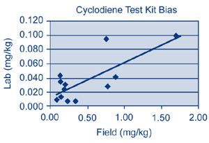
The quality of chemistry data was evaluated throughout the field effort to quickly identify inconsistent analytical results. For example, during early field work, immediate corrective measures were taken when immunoassay results were inconsistent with the preliminary CSM. The test results suggested a uniform distribution of contaminants across the entire study area, including areas known to have recently imported fill. The inconsistency was traced to an error with the soil sample extraction procedure, which was corrected quickly. The project team recognized that evaluation of collaborative data sets needed to reflect inherent differences in analytical methods, such as the positive bias incorporated into the immunoassay cyclodiene test kit (Figure 4).
During the course of field work, 78 primary samples (plus nine field duplicates) were analyzed by immunoassay, and 21 method duplicates were analyzed in the laboratory. The investigation revealed no pesticide hotspots on any of the properties but did find application residuals of DDT (and breakdown products) and cyclodienes. Upon review of the collaborative data set, the State and Region 9 were satisfied that the sites had been sufficiently characterized and that little or no soil removal was required.
The project team estimates that a minimum of one additional round of site investigation was avoided through the implementation of Triad. A detailed case study on this project will be available later this year on EPA’s CLU-IN web site.
For more information, contact Bradley Call, USACE, at 916-557-6649 or bradley.a.call@usace.army.mil, or Lily Lee, U.S. EPA/Region 9, at 650-853-3122 or lee.lily@epa.gov.
McGuire Air Force Base Completes Rapid Characterization at MILCON Project
The McGuire FASTRAC method employed the Triad approach to expedite site characterization at the McGuire Air Force Base C-17 aircraft hangar, a MILCON project scheduled for completion by July 2004. A PCE plume was discovered during early 2003 in shallow ground water near the hangar, at concentrations high enough to suspend construction activities. Conventional site characterization, risk assessment, and remedial planning were expected to take several years.
The Air Force Center for Environmental Excellence assisted base management in securing field contractors within two weeks. Field operations completed within 14 days involved:
- 15 MIP/cone penetrometer test (CPT) soundings with more than 4,500 discrete samples analyzed for aromatic and halogenated compounds;
- 25 CPT soundings with geophysical cones and fuel fluorescence detectors;
- 20 continuous soil cores logged by an onsite geologist for comparison to CPT-generated stratigraphic maps;
- 34 soil sampling locations with 234 discrete soil samples, and 42 ground-water sampling locations with 160 discrete ground-water samples analyzed for chlorinated VOCs using the DSITMS; and
- 60 soil and ground-water samples collected for confirmatory analysis by a fixed laboratory.
Site characterization was completed one day ahead of its six-week deadline. The project’s risk assessment led to immediate excavation of approximately 500 yards3 of soil from the area’s unsaturated zone. In accordance with the project’s DWP, field activities were adjusted to develop a data set of parameters for evaluating natural attenuation, which was found to be very active.
McGuire Air Force Base estimates that the Triad approach facilitated a savings of 18-24 months and $1.34 million. The project results allowed state and federal regulators to give conditional approval for an interim remedial action plan involving natural attenuation, and 12 natural attenuation monitoring wells were installed shortly thereafter.
For more information, contact John Pohl at McGuire Air Force Base, at john.pohl@mcguire.af.mil.
Triad Workshops, Training, and Conference Sessions
Interested in learning more about improved decision making at hazardous waste sites? Opportunities ranging from introductory training to detailed information exchange are offered at these upcoming events:
- 2004 AFCEE Technology Transfer Workshop, San Antonio, TX, August 16-19, 2004 (http://www.afcee.brooks.af.mil/products/techtrans/workshop/generalinfo.asp)
- Midwestern States Risk Assessment Symposium, Indianapolis, IN, August 25-27, 2004 (http://www.spea.indiana.edu/msras/)
- Sampling, On-Site Analysis and Sample Preparation Conference, Pittsburgh, PA, September 16-17, 2004 (http://members.aol.com/hnpacs/conferences/Conferences.htm)
- Streamlining Investigations and Cleanup Using the Triad Approach, St. Louis, MO, September 22-23, 2004 (http://www.trainex.org/classdetails.cfm?courseid=300&classid=2042)
- Triad Approach–A New Paradigm for Environmental Project Management, Interstate Technology and Regulatory Council’s Internet-based training, October 12, 2004 (http://www.itrcweb.org)
- Annual Conference on Soils, Sediments, and Water, Amherst, MA, October 18-21, 2004 (http://www.umasssoils.com/)
