![]() A newsletter about soil, sediment, and groundwater characterization and remediation technologies
A newsletter about soil, sediment, and groundwater characterization and remediation technologies
This issue of Technology News and Trends highlights innovative approaches to remediate and reclaim former mining sites and larger areas impacted by abandoned mining sites. Environmental problems associated with mine-scarred lands include revegetation difficulties, waste piles or dumps contributing to metal-loading in surface water, and acid mine drainage (AMD) deteriorating regional surface and ground water quality.
Passive Systems Treat AMD While Allowing Recovery of Metal Oxides
CLU-IN Resources
CLU-IN provides an online "issue area" to help stakeholders clean up and reclaim Mining Sites (http://cluin.org/issues/). Resources include a link to EPA's Abandoned Mine Land webpage, which contains site-specific case studies, technical information on geochemistry, characterization, and remediation, and research reports on unique aspects such as metals loading and attenuation.
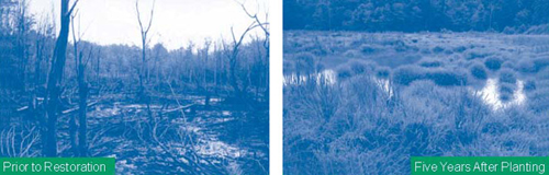
A public-private partnership is installing a series of passive treatment systems to treat AMD from abandoned surface and underground coal mines in western Pennsylvania. Since 1994, the Slippery Rock Watershed Coalition has constructed 16 systems annually treating over 750 million gallons of AMD. Each system typically employs a sequence of natural gradient-driven treatment steps involving settling ponds, vertical-flow ponds containing limestone and organic material such as compost, and constructed wetlands to treat surface water that is diverted from (and later returned to) mining-impacted streams. Under the state's Growing Greener Program, academic volunteers and the Pennsylvania Department of Environmental Protection (PA DEP) have noted significant improvements in water quality of receiving streams as well as a return of fish in about 11 miles of headwaters streams as a result of AMD treatment. Sale of metal oxides reclaimed from the treatment systems helps cover maintenance costs for existing systems and is anticipated to help install new systems addressing other abandoned discharges in the region.
PA DEP investigations in 1998 indicated that mine drainage into Seaton Creek, a major headwaters tributary, contributed 42% of the acid load and 49% and 41% of the iron and aluminum loadings, respectively, to Slippery Rock Creek. The findings focused cleanup efforts on Seaton Creek at a 40-year-old, 100-acre surface mine known as the De Sale Restoration Area. The target area for metal oxides recovery at this mine comprises an unnamed tributary with pH averaging 3.1 and acidity (the amount of base needed to neutralize a volume of water) of 100-450 mg/L. Metal concentrations in surface water range from 10 to 80 mg/L total iron, 20-80 mg/L total manganese, and 5-15 mg/L total aluminum. Stream flow ranges seasonally from 10 to 500 gpm.
Remedy construction included installation of a 16-ft-wide by 3-ft-high instream dam with 6-in and 8-in intake pipes allowing diversion of up to 700 gpm under the natural gradient into the treatment system. The entire stream (except during occasional storm events) is diverted into an 8,000-ft2 forebay to settle solids and debris. Upon exiting the forebay, water passively flows to two flushable vertical-flow ponds operating in parallel to neutralize acidity, raise pH, and remove metals. Each 20,000-ft2 pond contains 2,200 tons of limestone aggregate overlain by a 0.5-ft layer of spent mushroom compost. Iron oxides precipitate at low pH above the compost as water percolates down through the component.
Two tiers of perforated plastic pipe within the aggregate of each vertical-flow pond collect and transfer water to a 0.2-acre, 5-ft-deep settling pond. A riprap-lined spillway allows water to then pass to a 1.5-acre, free-flowing, aerobic, constructed wetland to precipitate amorphous iron hydroxides at circumneutral pH (Figure 1). Upon exiting the wetlands, water enters a horizontal-flow limestone bed containing 2,900 tons of limestone aggregate that removes manganese and provides an alkalinity boost for additional buffering capacity downstream. Treated water finally discharges through a 10-in pipe into a rock-lined channel that returns flow to the watercourse at a location approximately 1,000 ft below the intake.
The treatment system was constructed over six weeks in June-July 2000. Limestone (90% CaCO3) aggregate was obtained from a local quarry three miles distant at a material and delivery cost of $12/ton. Spent mushroom compost was obtained from an agricultural producer based 12 miles away, at a material and delivery cost of $10/yd3.
The system currently neutralizes approximately 180 pounds of acid discharge each day. Daily reduction rates for metals average 20 pounds of iron, 8 pounds of aluminum, and 25 pounds of manganese. Monitoring of surface water re-entering the stream after treatment typically shows a pH of 6-7 with total iron and aluminum concentrations less than 2 mg/L and manganese concentrations at least 50% lower than intake levels. Sampling of treated surface water in Spring 2008 indicated pH 6.7, alkalinity 60 mg/L, acidity -33 mg/L, dissolved iron 0.1 mg/L, dissolved aluminum 0.1 mg/L, and dissolved manganese 14 mg/L. These results represent 100% neutralization of the acid discharge and 99%, 99%, and 70% reductions of iron, aluminum, and manganese concentrations, respectively.
Efforts to recover manganese oxide from the horizontal-flow limestone bed began last fall. Recovery equipment for dewatering, separation, and handling of manganese-bearing material included a 21-metric-ton excavator equipped with a "flip screen" attachment to screen materials, a gasoline-powered water pump, and 1-yd3 bulk storage containers. About 30 tons of recovered material currently is stockpiled offsite, and an estimated 20 tons of material remain for future recovery. Additional drying and screening can be conducted before reuse, depending on user needs. Preliminary laboratory results indicate the unprocessed, recovered material consists of approximately 25% manganese oxide with the remainder constituting primarily quartz, limestone, and water.
A large-scale effort to recover the iron oxide precipitating at low pH is planned for later this summer. Recovery will employ a small excavator to remove an estimated 200 yd3 of material collected in the existing vertical-flow ponds. In order to provide continuous treatment, the process directs all raw water to one pond while recovering iron oxide precipitate from the other and vice versa. Recovered iron oxide will be used as pigments for bricks, concrete, and ceramics. Commercially available material of similar quality currently is sold in the area for about $0.50 to $1 per pound.
The non-profit Stream Restoration, Inc. assists the Slippery Rock Watershed Coalition in coordinating treatment system installation and maintenance. The partnership relies on field assistance from Grove City College, Westminster College, and Slippery Rock University students, mining companies, local residents, and other youth or service organizations. Recovered manganese and iron oxides have been used by local artists as colorants in ceramic glazes, and future markets are anticipated to include manufacture of "green" products such as tile and paint.
Since 2005, the PA DEP has awarded over $4 million in innovative technology grants to develop cost-effective industrial applications helping to treat the state’s estimated 23 billion gallons of AMD from active and abandoned coal mines. Other innovative strategies explored under the Growing Greener initiative include self-flushing limestone systems, steel slag as treatment media, and optimization and combination of passive treatment systems providing added value to site cleanup.
Contributed by Scott Roberts, Deputy Secretary of the Office of Mineral Resources, PA DEP (jayroberts@state.pa.us or 717-783-5338), Margaret Dunn, Slippery Rock Watershed Coalition, and Cliff Denholm, Stream Restoration, Inc. (sri@streamrestorationinc.org or 724-776-0161)
Ecological Approach Used to Remediate Former Mining Site
Cleanup of the inactive Burlington Mine site in Boulder County, CO, was initiated in 2003 as a voluntary cleanup overseen by the Colorado Department of Public Health and Environment (CDPHE) pursuant to the Colorado Voluntary Cleanup Redevelopment Act of 1994. An ecological approach was used to improve downstream water quality, reduce surface- and ground-water interaction with contaminated materials, and limit potential for subsidence. Activities included the filling and mounding of subsidence pits, realignment of intermittent tributaries, management of surface-water runoff, and revegetation of barren areas.
The 11-acre property was used by several companies from 1920 to 1973 to produce fluorspar (calcium fluoride), an active ingredient of fluorinated compounds commonly needed for water fluoridation and ceramic manufacturing. In the 30 years prior to cleanup, the site experienced significant and increasing subsidence. Site investigations in 1999 indicated acidic and metals contamination in waste rock onsite and in the adjacent surface-water drainage. Geotechnical investigations indicated a 12- to 15-foot layer of alluvium overlying bedrock at a depth of 25 feet below ground surface. Ground water is encountered at a depth of 8-10 feet.
Field preparation began with consolidation of 25,000 yd3 of acid-generating waste rock and closure of three onsite adits and shafts. Activities then focused on addressing three subsidence pits that provided direct paths for flow of contaminated material from the subsurface mine workings to surface and ground water. Of particular concern was a 1/3-acre pit that intercepted intermittent drainage from Balarat Gulch in the Lefthand Canyon watershed. Approximately 17,000 yd3 of uncontaminated or neutralized onsite soil was used to backfill the pits. Sufficient material was added to create a minimum 2% slope for discouraging infiltration and promoting runoff. In anticipation of the backfill settling, the area was over-mounded 4 feet.
Significant water interactions associated with Balarat Gulch were addressed by constructing a 500-ft diversion channel to realign drainage away from mine workings. The design used a step-pool configuration typical of high-gradient alpine streams, whereby system stability relies on closely spaced, low-profile drop structures (i.e., elevation reductions) to dissipate flow energy. Construction of the channel bed in this way helped to more closely imitate natural channel form and function, incorporate naturalizing elements, and create aquatic and riparian habitat.
Three-dimensional mining maps were used to identify the channel’s optimal centerline location and inversions. The channel design accommodated sizing and configuration sufficient to contain the design discharge of 264 cfs, which is 120% of a 100-year storm event. In an upper reach of the diversion channel, where realignment required a sharp bend away from the historic surface-water path, a PVC liner was installed to fully confine water and reduce potential for piping failure behind a constructed 10-ft-wide, 2-ft-high boulder wall. Two lower reaches of the channel were left unlined to allow hillslope ground water to access the new channel rather than flowing beneath it and potentially accessing the mine workings below.
The Balarat Gulch diversion channel required excavation at a steep (2:1- 2.5:1 horizontal:vertical) 1/2-acre sideslope. To prevent erosion, the slope was stabilized with a native seed mix including mountain mahogany (Cercocarpus montanus) and bitterbrush (Purshia tridentata) shrubs suited for optimal establishment on bedrock face microniches. Following seeding, the slope surface was amended with Biosol® prior to installing a biodegradable woven-coconut coir erosion control fabric.
A primary alluvial water control structure extending to bedrock was installed at the top of the diversion channel to address subsurface flow. The engineered structure comprises a 75-ft-long, 25-ft-deep impermeable liner and curtain drain consisting of prefabricated drainage panels with perforated PVC pipe threaded through bottom sleeves. The impermeable lining intercepts alluvial water and forces it into the curtain drain system. Localized ground water and surface water not intercepted by the primary control system are captured in a secondary, downstream "scavenger" drain.
Revegetation focused on stabilizing the site, promoting evapotranspiration, and preventing precipitation and subsurface infiltration. Preparations required surface application of agricultural lime to neutralize acid generation potential of the waste rock. Approximately 15 tons of lime were applied per 1,000 tons of waste rock throughout the backfilled areas. These areas were covered with 12-18 inches of native subsoil and topdressed with "type A" commercial compost at a rate of 60 tons per acre. This created a physical barrier to precipitation reaching the waste rock and provided a suitable medium for plant growth. A seed mix of native grasses, wildflowers, and shrubs was broadcast seeded at a rate of 240 pure live seed (PLS) per square foot. Shrub and tree plantings included over 220 riparian species such as thinleaf alder (Alnus incana), 150 upland shrub species such as wax currant (Ribes cereum), and 20 ponderosa pine trees (Pinus ponderosa).
A mobile bed of soil and rock gradations in the natural channel was used to allow mobilization by low-intensity storms, as in a natural, dynamic system. Material mobility results in natural scour and deposition cycles capable of forming localized pools or overly wide water flow. The mobile bed is underlain by a resistive, grouted riprap layer providing vertical protection against channel lowering. To replicate native conditions, natural rock and boulders were given preference over concrete during construction of the bed and bank treatments. Creating small notches in the tops of the drop structures in an alternating alignment encouraged development of low-flow channels with increased sinuosity.
After 12 months of remedy operation, corrective measures were required to address unanticipated drainage along the hillslope of Balarat Gulch. Deep rills had developed under the erosion control fabric due to interception of several small drainages and a ground-water seep caused by remedial excavation; in some areas, the fabric was stretched to failure by underlying erosion. Woody material was installed where possible to reroute flows and serve as supplemental breaks to drainage flows, and a subsurface drain system was installed to collect and route seep water around the vulnerable hillslope to more stable, vegetated areas. Large rills were regraded to the extent possible and erosion control fabric was re-installed in problem areas.
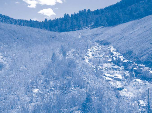
Wildlife protection methods included installation of Bird Balls™ recommended by the U.S. Fish and Wildlife Service to prevent waterfowl from landing or residing in a pond receiving constant discharge from underlying mine tunnel. After three growing seasons, vegetative coverage is as low as 5% (in sections of the steep 2:1 hillslope), but as high as 85% in other areas (Figure 2). Complete revegetation is expected to require 10-20 years. CDPHE estimates a total cleanup project cost of $1.5 million, or about $140,000 per acre.
Contributed by Angus Campbell, CDPHE (angus.campbell@state.co.us or 303-692-2000) and James Cowart and Julie Ash, Walsh Environmental Scientists and Engineers, LLC (jcowart@walshenv.com, jeash@walshenv.com or 303-443-3282)
Interagency Study Examines Impacts of Mine Spoil Types on Reforestation Efforts
The University of Kentucky, in cooperation with the U.S. Department of Interior (DOI) Office of Surface Mining, the Kentucky Department of Natural Resources, and the coal industry has initiated a research program to examine reforestation techniques on surface mined lands. Research plots were established on the Bent Mountain surface mine in Pike County, KY, for the purpose of evaluating the influence of three different loose-graded spoil types on tree performance, water quality, and hydrology.
Historically, reforestation was used to reclaim sites impacted by surface mining in the Eastern U.S. The passage of the Surface Mining Control and Reclamation Act of 1977 required that mined lands be returned to their approximate original contour (AOC). Spoil compaction involved in reconstructing sites to the AOC often hinders reforestation efforts, contributing to a decline in the amount, diversity, and productivity of forestland in coal-producing areas. Compacted soil and inappropriate geochemical characteristics often lead to high seedling mortality, slow plant growth, accelerated erosion, and deteriorated quality of receiving streams.
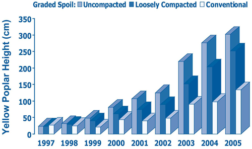
Previous research on mined lands has shown that loosely graded topsoil, weathered sandstone, and other non-toxic topsoil substitutes are suitable growing media for establishing native hardwood forests in Appalachia (Figure 3). Research is now helping to evaluate media other than topsoil and the influence of loose-grading techniques.
The Bent Mountain surface mine covers a total of more than 1,000 acres, including 150 acres of reforestation research areas. University of Kentucky researchers constructed one-acre test plots to evaluate three on-site spoil types: (1) predominately brown weathered sandstone (brown); (2) predominately gray un-weathered sandstone (gray); and (3) mixed weathered and un-weathered sandstones and shale material (mixed). Prior to placement of the spoil in each plot, a system of drain pipes and tipping buckets was installed on a stable mine surface to capture and measure infiltrated water that percolated through the spoil. Six to eight feet of the respective spoil material was end dumped from a truck on top of the drainage system in each plot. Four tree species (white oak, yellow poplar, red oak and green ash) were planted into the loose spoils at a rate of 800 per acre.
Physical and chemical characteristics of the spoils indicated that the brown spoil type exhibited a higher productivity potential than the gray and mixed spoil types due to a finer soil texture, higher cation exchange capacity, higher phosphorous concentration, and a pH more suitable for native hardwood trees. After three years, the gray spoil type had an overall higher mean tree seedling survival (88%) than the brown spoil (86%) and mixed spoil (81%), but no significant differences in survival were observed among spoil types. The brown sandstone plots however, showed significantly more growth in height and diameter than the gray and mixed plots. Mean tree volume index was 230, 80, and 40 cm3 for the brown, mixed and gray, respectively.
Results showed that loose-graded spoil exhibited low discharge volumes to surface water, small peak discharges, and long durations of discharge. Storm flow characteristics and mean runoff curve numbers were similar to that of an unmined reference forested watershed. Surface water interception and storage is expected to increase as the forest matures, thereby further reducing discharge volumes and peak discharges. Electrical conductivity (EC), as an indicator of water quality and ionic strength, decreased by 75% in the gray and mixed spoil types, while concentrations in the brown remained steady. After three years, EC levels for all spoil types were below 500 uS/cm—a reported threshold level for mayflies (Ephemeroptera), a pollution indicator species for headwater streams of the Central Appalachian Mountains.
Study results indicated that topsoil substitutes can be used effectively as growth media for native vegetation when combined with field techniques for loose grading and minimized surface compaction. Strategies relying on these techniques are being incorporated into a regional watershed restoration design that incorporates landscape modification, stream restoration/creation, and reforestation at a head-of-hollow fill in eastern Kentucky.
Contributed by Patrick Angel, Ph.D, DOI Office of Surface Mining Reclamation and Enforcement (pangel@osmre.gov or 606-309-4159) and Chris Barton, Ph.D (barton@uky.edu or 859-257-2099) and Carmen Agouridis Ph.D (cagourid@bae.uky.edu or 859-257-3000), University of Kentucky
The U.S. EPA and National Ground Water Association (NGWA) joint Remediation of Abandoned Mine Lands Conference will be held October 2-3, 2008, in Denver, CO. The agenda includes detailed discussion of characterization, source controls, treatment technologies, and reuse/reclamation strategies. More information and registration for this event is available from the NGWA at http://www.ngwa.org/development/conferences.aspx.
The U.S. EPA and federal partners such as the Agency for Toxic Substances and Disease Registry, National Institute of Health, and Department of Energy will sponsor the International Environmental Nanotechnology Conference: Applications and Implications on October 7-9, 2008, in Chicago, IL. Presentations will address nanotechnology applications for remediation of environmental contaminants, implications of releasing manufactured nanoparticles in the environment, and pollution control and nano-enabled sensing. Registration and a detailed agenda are available online at http://emsus.com/nanotechconf/index.htm.
The Groundwater Resources Association of California (GRAC) will convene its Emerging Contaminants 2008 Symposium on November 19-20, 2008, in San Jose, CA. Topics will include nanomaterials, pesticides/herbicides, pharmaceuticals, phthalates, and flame/fire retardants. For more information, visit GRAC online at http://www.grac.org/contaminants.asp.
