![]() A newsletter about soil, sediment, and groundwater characterization and remediation technologies
A newsletter about soil, sediment, and groundwater characterization and remediation technologies
- Innovative Organic Amendments Continue to Stabilize Slopes at Smelter Site
- EPA Convenes Ecological Restoration Workshop
- New Decision Tool Uses Vegetative Data to Plan Remediation Strategies
- Reclamation Strategy for Capped Landfill Aims Toward Woodland Restoration
- Biosolid Compost Reduces Lead Bioavailability at Inner-City Site
This issue of Technology News and Trends highlights the use of soil amendments in remediation, revitalization, and reuse of disturbed land in diverse industrial, rural, and urban settings. Using various waste products to reclaim previously unusable or devalued land, these soil-amendment applications illustrate that industrial residuals can provide a cost-effective means for in-situ remediation. Such success stories reflect the Agency’s growing efforts to identify innovative technology solutions for remediation and revitalization, to remove obstacles impeding redevelopment, and to develop measures for evaluating the various stages of ecological damage and repair.
Innovative Organic Amendments Continue to Stabilize Slopes at Smelter Site
One of the largest revegetation projects undertaken by the U.S. EPA’s Superfund Program used a mixture of sewage sludge, fly ash, and lime, and most recently, mushroom compost, lime, and fertilizer, to reclaim 1,400 acres of a former smelting site in Carbon County, PA. This site, known as the Palmerton Zinc Pile Superfund site, is located near the confluence of the Lehigh River and Aquashicola Creek. Primary smelting of concentrated zinc sulfide ores over the past century released large quantities of zinc, lead, cadmium, and sulfur dioxide. The smelting operation caused deforestation of more than 2,000 acres on the north slope of Blue Mountain.
By 1980, when all primary smelting operations ended, elevated metal concentrations had denuded the mountainside and stopped microbial decomposition of the dead trees. In addition, soil erosion had washed away 12-24 inches of topsoil and exposed underlying rock. Concentrations of metals, such as zinc, cadmium, and lead, in the upper 2 inches of remaining soil were approximately 100-fold higher than in ambient soil. Additionally, an estimated 33 million tons of slag had been dumped over the years, creating a cinder bank 2.5 miles long, 200 feet high, and 1,000 feet wide along the base of Blue Mountain.
Upon determining that removal of contaminated soil and associated smelting residue would cost more than $4 billion and take up to 45 years, EPA and potentially responsible parties began efforts in 1982 to stabilize the metals onsite through pH management and revegetation. The work area was designated as operable unit 1 (OU 1). Previous efforts to revegetate the site were unsuccessful due to steep slopes, eroded soil, and high winds as well as the soil’s metal toxicity, nutrient deficiencies, and absence of microbial activity.
Soil analysis and greenhouse testing of potential plants identified the most viable seeds to be planted in large-scale field plots. The selected soil amendment consisted of limestone (10 tons/acre), fly ash (132 pounds/acre), and municipal sewage sludge (21 dry tons/acre). This combination of materials provided necessary nutrients in a physical form that effectively adhered to the exposed rock layers without washing or blowing away.
Full-scale application began in 1991 with construction of a mixing area to blend limestone, sewage sludge, and fly ash simultaneously rather than through the series of spreading steps used during an earlier onsite pilot-scale application. Suitable biosolids (containing at least 20% solids) were obtained from municipal wastewater treatment facilities in Allentown, Warminster, and Philadelphia, PA, and fly ash was obtained from the Pennsylvania Power & Light’s facility in Montour, PA. Based on pilot-scale results, a 2:1 biosolids/fly ash ratio was used to provide initial grass cover for stabilizing the site while attempting to allow trees to germinate.
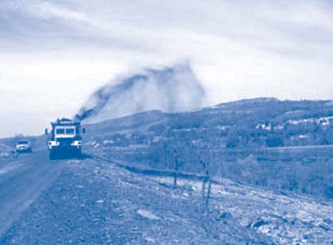
The amendment was mixed directly with tree forb and grass seeds such as intermediate wheatgrass, Canada bluegrass, perennial ryegrass, redtop, and birdsfoot trefoil, and applied once across approximately 850 acres (Figure 1). More than 60 miles of switchback roads were constructed on the mountain slopes to accommodate the application truck’s need for a relatively level road surface.
The U.S. Army Corps of Engineers evaluated the restoration project in 1995. They found that the amendment reduced soil erosion, decreased the amount of metals dissolving into runoff, and appeared to stabilize soil in the treatment area. Reclamation of the site was evidenced further by the return of wildlife, such as kestrels, red-tailed hawks, turkey, groundhogs, coyote, and fox. Establishment of grass cover was highly successful, but tree seedlings were choked by dense grass cover. Shading from grasses and predation by deer and small mammals also hampered tree establishment significantly.
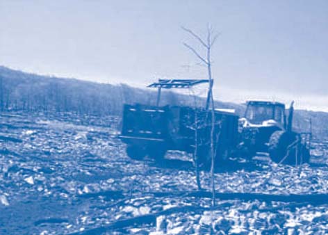
Over the past 10 years, this acreage has maintained more than 70% vegetative cover with increasing emergence of volunteer tree species. Follow-on field tests were initiated in 2003 to address 470 additional acres of OU 1. This portion of Blue Mountain has similarly rugged terrain and also suffered from denuding. To preserve the site’s topography and help convert the site to a wildlife refuge, private-property owners worked with EPA to identify alternative methods for applying amendments without construction of additional roads. Field experiments demonstrated that a caterpillar tractor with a modified agricultural spreader would allow materials to be applied effectively from the back of the vehicle while traversing rocky terrain.
This application method was used to add a new amendment on 220 acres of OU 1 this past spring (Figure 2). The amendment consisted of mushroom compost obtained from local mushroom farms, lime, and fertilizer mixed with native warm-season grasses. Leaf and grass-clipping compost from a local municipality was used occasionally when mushroom compost was unavailable. To accomplish revegetation of the remaining 250 acres with difficult access and grades exceeding 25%, an aerial crop duster applied a mixture of seeds, fertilizer, and lime.
These enhanced application techniques effectively preserved the natural landscape of Blue Mountain. Visual inspection of the acreage treated this year indicates significant germination; in August, germination counts and species identification will be completed. The compost-based amendment is expected to achieve a vegetative cover equivalent in percent to that obtained from a biosolid amendment while avoiding perceived negative impacts sometimes associated with biosolids.
Implementation of this strategy at the 850 acres initially treated, including road construction, was estimated to cost $9 million. Use of the modified equipment, which required no road construction, significantly reduced implementation costs for the follow-on field tests.
Contributed by Charlie Root, U.S. EPA Region 3 (root.charlie@epa.gov or 215-814-3193)
EPA Convenes Ecological Restoration Workshop
National experts gathered at the U.S. EPA’s Region 5 office in Chicago, IL, in August to begin developing a white paper promoting remediation, revitalization, and reuse of contaminated properties using soil amendments. The white paper will address considerations for the use of a number of different amendments, and will include a decision matrix for identifying technical performance measures for amended soil. Updates on this work will be posted on CLU-IN (http://cluin.org).
New Decision Tool Uses Vegetative Data to Plan Remediation Strategies
Private industry and academia collaborated with the U.S. EPA in developing a decision tool that uses data on existing vegetation to identify appropriate cleanup methods for distinct portions of large waste sites. Implementation of this new tool, known as the Riparian Evaluation System (RipES), began in August at Montana’s Clark Fork River OU, a 120-mile-long stretch along the river with extensive fluvial deposition of acid metalliferous mining wastes. As part of the comprehensive Milltown Reservoir/Clark Fork River Superfund Site, the OU record of decision (ROD) specifies cleanup remedies such as removal of some wastes from 170 acres, in-place treatment of 700-1,700 acres of wastes using lime and organic matter as amendments, and stream-bank stabilization using a soft engineering approach. This approach involves use of vegetation with deep and binding root systems such as willow and water birch to minimize streambank erosion.
RipES employs key indicators of landscape stability and plant community dysfunction to categorize clearly delineated portions of the site as unique “polygons.” Each polygon is associated with an exact location, surface area, waste volume, and other attributes that are displayed as geographic information system layers over base area photographs. Remedial design teams can then link each polygon to one or more of the ROD-specified remedial actions and more precisely define cleanup costs. The tool provides:
- Classification of stream-bank lengths according to three stability types, and descriptions of landscape polygons with varying levels of contamination and vegetation dysfunction,
- Numerical components segregating stream-bank lengths into different classes, and threshold scores distinguishing severity of vegetative dysfunction, and
- A process for identifying field data gaps and needed information for remedial designs of each landscape polygon and stream-bank length.
RipES was applied to multiple locations at the OU during 2002 in order to calibrate and validate the system, and was demonstrated to project stakeholders in the field the following year.
Each remedial area of the OU now will be classified as one of four major types: (1) stream-bank length classified by stability type, (2) slicken areas (exposed tailings), (3) impacted soils and vegetation areas, or (4) slightly impacted soil and vegetation areas. For each of these areas, a RipES score will be derived to determine the most appropriate cleanup remedy allowed by the site’s record of decision.
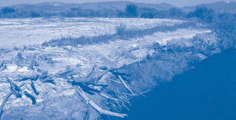
Landscape and contaminant conditions vary widely across the OU. For example, field tests identified a representative area comprising both a stream bank and slickens area with barren areas and little woody or herbaceous vegetation (Figure 3). Analytical sampling indicated that the area contained metal salts, copper concentrations in soil averaging 1,770 ppm, and a pH averaging only 4.5. A low RipES score identified this as a polygon with high priority during remediation planning.
By early September, field teams had classified 11 miles and identified remedial polygons of the floodplain streambank. Remediation planners for the Clark Fork River OU anticipate the use of RipES over the next several years. The system also may be used at this and other large sites to establish treatment performance standards, evaluate land reclamation designs, and monitor ongoing reclamation projects.
More information on the Milltown/Clark Fork River application is available on EPA Region 8’s Superfund web site (http://www.epa.gov/region8/superfund).
Contributed by Dennis Neuman, Reclamation Research Group (dneuman@reclamationresearch.net or 406-570-9274), Paul Hansen, Ecological Solutions Group (paul_hansen@ecologicalsolutionsgroup.com or 406-777-1881), and Kristine Knutson, U.S. EPA Region 8 (knutson.kristine@epa.gov or 406-457-5021)
Reclamation Strategy for Capped Landfill Aims Toward Woodland Restoration
Revegetation of a portion of the Fresh Kills capped landfill on Staten Island, NY, illustrates an effective approach for urban site restoration and brownfields redevelopment. Revegetation relies on the process of natural biological succession to reclaim large-scale, self-sustaining woodland areas and restore natural habitats. Long-term field test results demonstrate the benefits of re-introducing native woody plants and relying upon the remnant natural landscape to accelerate reclamation at Fresh Kills. Field monitoring shows no evidence that roots of the woody plants have penetrated or otherwise compromised integrity of the landfill cap.
The 3,000-acre facility accepted all waste generated by the City of New York from the early 1940s to early 2001. It briefly closed but soon partially reopened to receive debris from the World Trade Center. Before closure, the City installed a conventional clay cap including a standard geomembrane and 2 feet of grass-covered soil. Routine maintenance of the cap involves twice-yearly mowing of the top grass to prevent growth of woody plants with roots capable of cap penetration.
Rutgers State University of New Jersey examined historic ecosystems of the Fresh Kills area and selected suitable species for planting in a 20-acre test section of the landfill cap. Tree saplings averaged 8 feet in height when planted, and shrub heights averaged 2 feet. In 1992, 700 individual plants representing seven species of native trees and shrubs were planted, including hackberry, blueberry, blackberry, pasture rose, beach plum, shadblow, and sumac. To minimize project costs, plantings were conducted in clusters rather than throughout the entire test site.
Within one year, seed propagation and viable root growth were observed in approximately 20% of the plantings. Within another year, more than 1,000 woody seeds representing 29 species were found onsite, of which 23 were native to North America. Distribution patterns indicated avian dispersal of 71% of the new seeds, primarily near “parent” clusters. An increased emergence of plants during the third year corresponded to the recent presence of 50 species of bees that visited flowers and helped generate thousands of new seeds enhancing future plant density.
Additional onsite testing was conducted to determine whether optimal revegetation results are achieved through numerous small clusters or fewer large clusters of plantings. Fast-growing native woody species were planted in clusters of 7, 21, 42, and 70 seedlings among a total of 20 clusters, including five clusters of each size category. Using one-meter-square seed traps, seed dispersal was quantified at various distances from parent clusters. Results showed that plantings of fewer but larger patch sizes (70 plants) propagated at higher rates than small clusters, though all clusters spread outward to eventually join one another. Seed distribution analysis also showed higher dispersal rates near forest remnants; over 30% of the seed “rain” from the nearby native woodland landed in the four nearest clusters.
Investigations were conducted over three years on woodland species growing over caps at other northeastern U.S. landfills, such as the former New Jersey Meadowlands municipal landfill. Analysis of uprooted woody plants indicated that their roots generally remain in the upper soil horizon, in the presence of water and air, and rarely extend more than 25 centimeters below the surface. In addition, currently available geomembranes were found to be stronger than woody plant roots, which tend to “pancake” outward when encountering a cap rather than penetrating it.
Climatic factors, such as precipitation, volume, and wind velocity, did not appear to negatively impact the use of woody plants for revegetation above caps. As anticipated, poor germination rates were observed in landfill areas with low microbial and earthworm activity. Multiple-site studies complemented the Fresh Kills findings regarding the positive influences of proximate forest remnants; destruction of 50% of nearby natural woodland vegetation generally leads to a significant decline in seed rain.
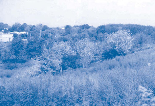
General unit costs are estimated at $3,000/acre for grass and $12,000/acre for woodland planting, exculding the costs for soil preparation and the recommended two years of watering. Monitoring of the Fresh Kills landfill test area is conducted every 1-1.5 years through funding from the National Science Foundation. Inspection of the site in late 2005 indicated continued growth of woodland areas (Figure 4) and increasing populations of avian and small mammal communities. Complete reclamation of this area, including an extensive public park, is anticipated by 2025.
Contributed by Steven Handel, Ph.D., Rutgers State University (handel@aesop.rutgers.edu or 732-932-4516) and John McLaughlin, State of New York/Department of Environmental Conservation (jmclaughlin@dep.nyc.gov or 718-595-4458)
Biosolid Compost Reduces Lead Bioavailability at Inner-City Site
The U.S. EPA and Department of Agriculture’s Natural Resources Conservation Service demonstrated an alternative, cost-effective approach for stabilizing lead contaminants in soil of inner-city sites. The demonstration was conducted in East St. Louis, IL, a region formerly supporting heavy industries, such as paint production and lead smelting, that released a range of contaminants.
In 1999, the State of Illinois determined that an extremely high incidence of lead poisoning among youth in East St. Louis was associated with proximity to several of these sites. The demonstrated stabilization approach uses municipal biosolids, fertilizers, and other modifiers to physically bind the lead to soil particles, thereby reducing bioavailability of the lead and preventing it from leaching into neighboring properties.
Goals of the demonstration focused on establishing field processes, equipment, and evaluation methods and identifying material suppliers. The demonstration occurred at a 2-acre site formerly used for metal forging and housing but more recently hosting only concrete rubble and a 75% mixed vegetative cover. The site’s close proximity to a school and community center encouraged its use as a school access route and playground for neighborhood children. Onsite x-ray fluorescence screening confirmed by laboratory analysis showed that lead concentrations in soil exceeded the project’s 400 mg/kg remediation goal at 17 of the site’s 34 screening points.
Prior to active treatment, the demonstration area was cleared and enclosed by a 4-foot construction fence, and restricted-access signs were posted at the school yard interface. The primary soil amendment consisted of non-acidic phosphorous, calcium carbonate, and “class A” biosolids containing 60% yard waste and 40% solid waste. Earlier studies suggested an application rate of 2:1 moles of phosphorous to lead, and sufficient calcium carbonate for raising and maintaining the soil pH from an average of 6.7 to a minimum of 7.0. A total of 250 pounds of “0-45-0” triple-phosphate fertilizer and 4,000 pounds of pelletized limestone were blended onsite and applied to each acre during a single pass using a standard tractor and chisel plow. Application rates were doubled in one corner of the site to address a lead hotspot. After mixing in the phosphorous/calcium carbonate, secondary debris removal was required to address a larger volume of rubble than anticipated.
Biosolids were obtained from the nearby City of St. Peters landfill and municipal treatment facility at no material cost. A tractor, conventional “beater” spreader, and more innovative “slinger” spreader were used to apply biosolids at a rate of 400 cubic yards (100 dry tons or 500 wet tons) per acre, producing a 3- to 4-inch layer of compost mat across the entire site. The material was mixed directly into the soil through two rounds of disking at perpendicular angles. This was followed by soil leveling with a harrow, and dispersion of “12-12-12” standard grass fertilizer at a rate of 150 pounds/acre. Fescue and winter wheat seeds then were broadcast at rates of 425 pounds and 2 bushels per acre, respectively, and mixed into the soil with the harrow. Following several days of precipitation, 15 tons of finely chopped straw were manually distributed.
Within one month, a 2- to 3-inch stand of fescue and winter wheat existed across 100% of the site. Five analytical samples were collected at each of five locations in December 2001, two months after treatment concluded. Results indicated that average lead concentrations in soil decreased from 776 mg/kg before treatment to 365 mg/kg after treatment. Using EPA’s SW-846 Method 3050A, lead bioaccessibility values were estimated to decrease 14%, from 75.6 to 64.7 mg/kg. The initial reductions are attributed to physical bonding of lead to soil particles as well as soil dilution factors. More recent reductions are attributed to ongoing biological processes enhanced by the presence of organic compost. Follow-up sample analysis in 2005 indicated that lead concentrations in soil remained below the target 400 mg/kg.
These demonstration results are consistent with earlier studies at the Oronogo Mining Belt Superfund site in Joplin, MO, which suggested a 69% reduction in bioavailability to humans may be achieved through this stabilization approach. Several steps are being taken to maintain the dense turf barrier: mowing on a weekly basis during growing seasons, applying four rounds of balanced fertilizer each year, adding more lime when annual tests indicate pH levels are below 6.5, and periodically adding non-acid phosphorous to ensure continued bonding between lead and soil particles.
Southwestern Illinois Resource Conservation and Development, Inc., a non-profit organization working with East St. Louis communities to address environmental concerns, reported a demonstration cost of $50,000 (excluding ongoing maintenance). This stabilization approach is suitable at commercial or industrial redevelopment sites where the turf barrier will not be disrupted and where regular mowing and other maintenance can occur; it is not intended for residential or recreational properties. Some communities and state agencies regulate the field application rates and location of biosolids. Since municipal waste treatment facilities produce biosolids daily, additional work is needed to promote use of this natural product as a remediation tool.
Contributed by Kevin Turner, U.S. EPA Region 5 (turner.kevin@epa.gov or 618-997-0115) and Dave Eustis, Southwestern Illinois RC&D, Inc. (dave.eustis@rcdnet.net or 618-566-4451)
