
- Featured Articles
- Demonstration: Classifying Munitions on FUDS Properties at the Former Spencer Artillery Range
- Demonstration: Munitions Potentially Affecting Groundwater at an Inactive Operational Range on Camp Edwards
- Demonstration: Munitions Classification Supporting Removal Actions at Former Camp San Luis Opisbo
- Resources
- EPA Website: Military Munitions/Unexploded Ordnance
- DoD Website: Military Munitions Response Program
- QA Planning: Advanced Geophysical Classification for Munitions Response (AGC-QAPP) Template
- Organizational Accreditation: DoD Advanced Geophysical Classification Accreditation Program
- ITRC Guidance: Geophysical Classifications for Munitions Response
- CLU-IN Webinar Series: Military Munitions Support Services
 Download This Issue in Adobe PDF® Format
(1.14MB/9pp/PDF)
Characterizing and remediating a site where munitions were used has traditionally involved use of geophysical survey systems to map the locations of detected subsurface metallic objects (anomalies) in locations such as munitions open burn/open detonation (OB/OD) disposal areas and former mortar and artillery range impact areas, and excavating all detected anomalies. Many of the subsurface anomalies do not correspond to munitions but to nonhazardous metallic objects or geology, which can lead to excavation of non-munitions items.
Since 2007, the U.S. Department of Defense (DoD) Environmental Security Technology Certification Program (ESTCP) has conducted more than 20 demonstrations of a munitions classification system aimed at maximizing recovery of subsurface munitions while minimizing excavation of non-hazardous metallic items (clutter). Each demonstration spanned multiple years and addressed one or more of the primary objectives of the classification pilot program: verify systems previously pilot tested at other sites; demonstrate prototype systems; and increase the difficulty of demonstrations over time by adding complexities such as multiple types of munitions or challenging site terrain. Some of the demonstrated geophysical sensors are prototypes developed earlier under the federal interagency Strategic Environmental Research and Development Program (SERDP). Completed and ongoing demonstrations adhere to a general process flow.
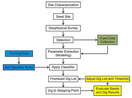
General process flow of each munitions classification demonstration
(Implementing Advanced Classification on Munitions Response Sites:
A Guide to Informed Decision Making For Project Managers, Regulators, and Contractors;
ESTCP Final Report, December 2011)
Articles featured in this issue of Technology News and Trends describe demonstration of the munitions classification system at three sites. At each site, the Geonics, Inc. EM-61 MK2 metal detection system was used to conduct initial surveys that generated baseline data indicating optimal locations at which to deploy the advanced geophysical sensing systems. The EM-61 MK2 is one of the most common industry standard production geophysical survey methods currently used but has very limited classification capability. Four advanced geophysical sensors, each of which is specially designed to maximize detection and classification of munitions, were used in the demonstrations:
- Berkeley UXO Discriminator (BUD) developed by the Lawrence Berkeley National Laboratory: a prototype hand-maneuvered system containing three orthogonal transmitters and eight differenced receiver pairs capable of continuous sampling and decay curve measurement 1.2 milliseconds (ms) after turnoff.
- Geometrics MetalMapper: a commercial system containing three orthogonal 1-meter by 1-meter (m) transmitters for target illumination and seven three-axis receivers for recording the EMI response decay, which are capable of sampling to 8 ms after turnoff. Its operation requires a vehicle for maneuvering and a global positioning system.
- Man-Portable Vector (MPV), originally developed by the U.S. Army Corps of Engineers' Cold Regions Research and Engineering Laboratory and SERDP: a hand-held wand with a single-dimensional 50-centimeter (cm) diameter transmitter head and five 3-axis receiver cubes containing three air-induction 8 cm square coils. The MPV can be programmed for a custom sampling duration and manually manipulated to obtain three-dimensional views of a target through a built-in laser positioning system. The MPV system is still under development and not yet commercialized.
- Time Domain Electromagnetic Multi-sensor Towed Array Detection System (TEMTADS), developed by the Naval Research Laboratory: The system is configured as a "5x5" array comprising 25 sensor elements spanning 2 m by 2 m or as a "2x2" array containing four transmitters spanning 80 cm by 80 cm; both configurations can collect data until 25 ms after turnoff. The sensor elements are mounted on a towed platform or hand cart.
Completed demonstrations suggest the classification process and associated use of advanced electromagnetic (EM) sensors can significantly reduce the cost of a munitions response. Use of the classification process may not be able to resolve the individual buried metallic items in areas with very high densities of anomalies, such as OB/OD units or heavily impacted target areas. However, the greater the knowledge and experience of the operator with the software that analyzes overlapping signatures, the greater the success in classifying individual targets. The importance of individual and team experience was exemplified during the final two years of the classification pilot program, when all demonstrators correctly classified 100% of the TOI and in most cases correctly eliminated 80% of the clutter.


Demonstration: Classifying Munitions on FUDS Properties at the Former Spencer Artillery Range
Contributed by Contributed by Harry Craig, U.S. EPA Region 10; Herb Nelson, U.S. Naval Research Laboratory
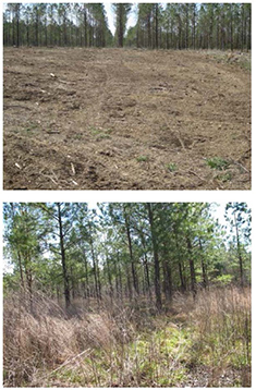
Figure 1. Vegetation in the open (top) and wooded (bottom) areas at the former Spencer Artillery Range.
At the former Spencer Artillery Range near Spencer, Tennessee, the Environmental Security Technology Certification Program (ESTCP) and several partners conducted field demonstrations of four advanced electromagnetic sensors in 2012: MetalMapper, TEMTADS (5x5 and 2x2 configurations), BUD and the MPV. The general objective was to discriminate targets of interest (TOI) (including 37-millimeter [mm], 60 mm, 75 mm, 105 mm, 155 mm, and small and medium industry standard objects [ISOs]) from non-hazardous shrapnel, range debris and non-munitions debris such as household items and automobile parts. TOI were correctly identified over 99% of the time by MetalMapper, the TEMTADS sensors and the MPV, while eliminating over 69% of the clutter. A modified version of the BUD sensor was not successful in this application.
The 30,620-acre former Spencer Artillery Range was used by the U.S. Army for troop training from 1941 to 1944, and as an air-to-ground gunnery range from 1944 to 1946. Two impact areas have been documented: Jakes Mountain (5,060 acres) and Bald Knob (2,090 acres). Several surface decontamination sweeps have been completed on portions of the site. Known munitions that remain include 37 mm, 75 mm, 76 mm, 105 mm and 155 mm projectiles. Factors considered in selecting the former Spencer Artillery Range for demonstration include its heavily wooded areas and the variety of munitions that were anticipated on the site.
The demonstration site was divided into three areas differentiated by the sensors deployed: an "open" area, a "treed" area (Figure 1) and a "dynamic" area. The 4.28-acre open area was surveyed in a cued, static mode for classification by the TEMTADS 5x5 and MetalMapper. A more challenging, 3.73-acre treed (wooded) survey area was surveyed by cued portable sensors including the hand-held BUD, MPV and TEMTADS 2x2. The 1.23-acre dynamic area, which is clear of trees, was surveyed by the TEMTADS 2x2, MPV and MetalMapper in both cued and dynamic (detection) modes to compare the deployment modes for identical targets.
Prior to initiating the deployments, all visible metal objects were removed from the surface. The final 9.24-acre demonstration site was seeded with enough TOI to ensure statistical validity on measures of classification of TOI (175 total targets throughout). The seeds included small and medium ISOs in addition to inert projectiles. The ISOs were also considered TOI and expected to be both detected and correctly classified. To ensure conditions remained realistic, the site preparation teams replaced any metal dug up during emplacement back in the hole with the seeded object. An initial detection survey was performed with an EM-61 MK2 with centimeter-level GPS navigation. These data were used to provide a common anomaly list for the MetalMapper and TEMTADS data collections that were to follow. EM-61 MK2 data were not used for classification.
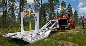
Figure 2. MetalMapper deployed onsite for data collection in cued mode.
An area free of munitions was located near the demonstration area to establish an instrument verification strip (IVS), which was used for daily verification of proper sensor operation. The IVS was seeded with inert munitions and small and medium ISOs. The data collection teams for all sensor deployments visited the IVS twice daily to verify equipment function at the start and end of each day. The seeds provided sufficient TOI to allow a statistically defensible determination of the correct classification in the absence of native unexploded ordnance. A clutter-free training pit also was established to collect sensor data for algorithm training. Daily calibration efforts consisted of periodically collecting background datasets in these areas throughout the day to determine the system background level for subtraction.
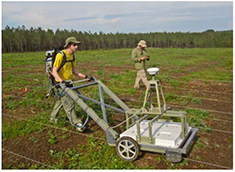
Figure 3. Deployment of TEMTADS 2x2 along closely-spaced parallel transects in the dynamic area at the former Spencer Artillery Range.
MetalMapper (Figure 2) and both the 5x5 and 2x2 TEMTADS array deployments were conducted in the spring of 2012. The 2x2 array was used in cued mode over 689 anomalies in the wooded area, and in both cued and dynamic modes over 340 anomalies in the dynamic area. The 5x5 array was used in cued mode in the open area. MetalMapper was used in cued mode to investigate 1,104 anomalies in the open area, and in both cued and dynamic modes to investigate 340 anomalies in the dynamic area. Cued mode data collection consisted of surveying static data over a list of anomalies identified from the EM-61 MK2 survey, while dynamic survey mode included complete coverage of the designated dynamic area where data were collected along parallel transects with 0.5 m nominal transect spacing (Figure 3).
The MetalMapper was successful in detecting 99.5% of anomalies in cued mode where the center of the instrument was positioned within 40 cm of the actual target location, while TEMTADS arrays detected 100% of TOI under this criterion. TOI were correctly classified in cued mode over 99.7% of the time with both MetalMapper and TEMTADS while eliminating 69 to 87% of the clutter. Classification performance was found to depend on analyst experience, suggesting that continued analyst training is an important component of technology transfer for these systems.
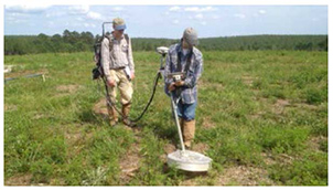
Figure 4. The MPV sensor was deployed in both treed and dynamic areas in cued and dynamic modes at the former Spencer Artillery Range.
The MPV sensor was deployed at the site for 12 days (Figure 4). Similar to other demonstrations, cued interrogation soundings were collected around the marked target location (ground paint or flag). The first sounding was acquired at the marker. In general, the operator followed a standard five-point square pattern (Figure 5). The sensor was checked by surveying twice a day over the IVS. The detection (dynamic) survey was performed by walking along pre-defined survey lines.
Cued interrogation with the MPV involved deployment in the treed area and covered about 700 flags. Approximately 99% of the TOI were found while rejecting about 85% of the clutter. Although some 75 mm projectiles were mistaken for medium-sized ISO, the caliber of TOI was predicted correctly 92% of the time; differences in caliber were negligible 98% of the time. In general, prediction of the target caliber was very reliable at the site, with the predicted target depth and location and the ground truth validation in close agreement with one another.
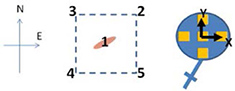
Figure 5. A cued survey pattern with five points centered on marked target location.
Dynamic collection began in the dynamic area on the fourth day of the MPV demonstration and concluded within about 20 hours. Approximately 300 potential targets were tested and followed by cued interrogation of the detected anomalies. All targets of interest were found while rejecting 90% of the clutter, which indicates a strong potential for significantly reducing the number of anomalies that need to be investigated in cued mode for future studies.
Environmental Security Technology Certification Program. Classification Demonstration at the former Spencer Artillery Range, TN Open Area. Summary Report. January 2014. Environmental Security Technology Certification Program. https://serdp-estcp.org/content/download/23734/239935/version/2/file/Summary+Report+-+Former+Spencer+Artillery+Range.pdf
Environmental Security Technology Certification Program. Demonstration of Advanced Geophysics and Classification Technologies on Munitions Response Sites, Former Spencer Artillery Range, Van Buren County, Tennessee. Final Report. June 2013. https://serdp-estcp.org/content/download/20410/216724/version/6/file/MR-201161-DR-Spencer+Range.pdf
Environmental Security Technology Certification Program. ESTCP Live Site Demonstrations Former Spencer Artillery Range, Spencer, TN. Technical Report. January 2013. https://serdp-estcp.org/content/download/18368/203550/file/MR-201165-TR-Spencer%20Range.pdf
Environmental Security Technology Certification Program. Dipole Models for UXO Discrimination at Live Sites — Feature Extraction and Classification of EMI Data, Former Spencer Artillery Range, TN. July 2014. https://serdp-estcp.org/content/download/29850/289476/version/2/file/MR-201159-TR.pdf
Environmental Security Technology Certification Program. Implementing Advanced Classification on Munitions Response Sites: A Guide to Informed Decision Making For Project Managers, Regulators, and Contractors. Final Report. December 2011. https://www.serdp-estcp.org/content/download/12780/151578/version/2/file/ Implementing_Classification_on_Munitions_Response_Sites_FR+with+Appendix+A.pdf
Environmental Security Technology Certification Program. Man-Portable Vector (MPV) EMI Sensor for UXO Contamination Assessment at Former Spencer Artillery Range, Tennessee. Final Report. April 2013. https://serdp-estcp.org/content/download/19153/209126/version/2/file/MR-201158-DR.pdf
Geometrics. Success Stories: Pilot Program Demonstrates Successful UXO Classification at Increasingly Complex Sites. In Fall 2010 Information Bulletin. http://www.geometrics.com/files/success-story---serdp-fall-bulletin.pdf
Geometrics. MetalMapper Manual, Preliminary. Manual. July 2011. http://www.geometrics.com/files/metalmapper_manual_beta1.pdf
Demonstration: Munitions Potentially Affecting Groundwater at an Inactive Operational Range on Camp Edwards
Contributed by Jane Dolan, U.S. EPA Region 1
Classification using the MetalMapper and TEMTADS advanced electromagnetic sensors was demonstrated at the central impact area (CIA) of Camp Edwards on the Joint Base Cape Cod (former Massachusetts Military Reservation) in Massachusetts. The demonstration objective was to detect and correctly classify targets of interest (TOI), with emphasis on removing potential sources of groundwater contamination. The demonstration also provided a training opportunity for field staff working with the sensors and analysts working with the data. The demonstration indicated that use of MetalMapper and TEMTADS successfully classified more than 90% of the TOI and eliminated 50-80% of the clutter.
The CIA was used for artillery and mortar testing from the late 1930s until 1997. During the late 1940s, the area also had air-to-ground rocket firing ranges. Various types of munitions (including 37-millimeter (mm), 40 mm, 75 mm, 90 mm, 105 mm and 155 mm artillery projectiles as well as 50 mm, 60 mm, 70 mm, 81 mm, 3-inch and 4.2-inch mortars) have been fired into the CIA. In addition, a 155 mm low-intensity training round (LITR) was utilized. High explosive munitions that did not explode (unexploded ordnance [UXO]) or that partially functioned accumulated within the area. The area is densely vegetated and ranges from relatively flat to heavily cratered terrain. Site characterization indicated that minimal interference attributable to subsurface geology could be expected during deployment of geophysical sensors; however, the subsurface contained a very high density of clutter.
Munitions of primary concern based on their incidence were 60 mm, 81 mm, and 4.2-inch mortars and 105 mm and 155 mm projectiles. Priority was given to maximizing removal of munitions constituents (by net explosive weight). For this demonstration, all items that could be potential groundwater contamination sources were considered TOI. This included intact rounds and substantial parts of rounds that could contain significant quantities of explosives. Since geophysical measurements cannot determine whether a round contains explosives, the TOI included UXO as well as inert items such as 155 mm LITRs.
Preparation of the 6-acre demonstration site began in 2012 through use of remotely-controlled heavy equipment with tree and brush cutting attachments to remove vegetation. The site was then surveyed with an EM-61 MK2 unit modified to discriminate small metallic clutter. All anomalies with amplitude greater than 27 microvolts (mV) of the EM61 were automatically selected; anomalies below this threshold were picked by hand. (The threshold value of 27 mV, which is background in a large portion of the CIA, can be attributed to a 60 mm mortar at 18 inches below ground surface.) After the survey, inert munitions and medium industry standard objects (2-inch nominal by 8-inch pipe nipples) were seeded. The anomaly selection criteria were weighted toward larger items that pose the most risk of groundwater contamination, which provided no guarantee that smaller munitions such as 37 mm projectiles would be found.
The vehicle-borne MetalMapper or portable TEMTADS 2x2 cart were used to collect cued data over each anomaly as well as the quality control seeds. A total of 4,722 anomalies were identified on the demonstration grids, a density approaching 800 anomalies per acre.
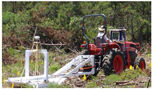
Figure 1. Deployment of MetalMapper at Camp Edwards through a sled configuration.
MetalMapper data were collected (Figure 1) over 2,273 of the 2,287 anomalies in 12 grids with relatively flat terrain in the southern portion of the demonstration area. Fourteen anomalies for which data collection was blocked by vegetation were placed at the top of the dig list. The most common quality control failure related to MetalMapper was positioning; if the separation between the MetalMapper center and the anomaly location was more than 40 cm, the anomaly was revisited the next day and additional data were collected within the 40 cm specification. The data collection team averaged 227 cued anomalies per day (32 per hour). Slightly more than 1% of the anomalies required re-measuring.
The TEMTADS cart was deployed over 12 grids on cratered terrain in the demonstration area's northern portion, where the sensor array was carried rather than pulled or pushed (Figure 2). Cued data were collected on 1,313 anomalies at an average rate of 250 anomalies per day. Only nine re-measures (less than 1%) were required. TEMTADS also was used in the southern area to compare its performance to MetalMapper's on approximately 300 anomalies.
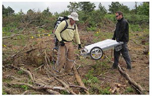
Figure 2. TEMTADS deployment at Camp Edwards involving a backpack-mounted data acquisition computer; a second operator controlled data collection through use of a personal data assistant communicating wirelessly with the data acquisition.
The nearly 5,000 anomalies identified in the 24 grids chosen for the demonstration were deemed roughly twice the number for which resources were available for full investigation during the demonstration. As a result, the demonstration was split into two phases; approximately half of the cued targets were classified, intrusively investigated and scored in the first phase. The remaining 3,380 cued targets would be addressed in a second phase when additonal resources became available.
A total of 1,336 anomalies were intrusively investigated during the first phase. The recovered items (and recovery totals) were categorized as UXO (8), other TOI (129), munitions debris (3,776) and other debris (85). No items were found at the locations of three investigated anomalies. The number of UXO recovered in the demonstration area indicates that UXO may serve as a source of groundwater contamination in other portions of the CIA.
Consistent with earlier demonstrations, the profiency of analysts working with advanced sensing data was critical to overall success in using the classification system. All analysts working with MetalMapper data correctly classified 95% or more of the targets of interest and four out of five eliminated more than half of the clutter. Analysts working with TEMTADS data achieved comparable results.
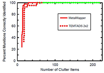
Figure 3. Results of Dartmouth College team analysis of Camp Edwards MetalMapper and TEMTADS data from overlap anomalies.
A comparison of classification performance achieved by one demonstration team using both MetalMapper and TEMTADS indicated virtually indistinguishable results for an anomaly subset (Figure 3). This correlation suggests that either sensor could be used effectively at this site, with terrain likely serving as the determining factor. Phase 1 cost analysis suggested that use of the munitions classification system at a comparable, 30-acre site could reduce response action costs by as much as 55%, based on avoided clutter digging.
During the second phase of munitions classification conducted in 2013, MetalMapper analysis of the 1,049 anomalies identified in the southern area resulted in excavation of 5,109 items, including 115 TOI. TEMTADS was used in the northern area during the second phase to evaluate nearly 1,300 anomalies; of these, 173 were identified as likely TOI.
Ultimately, 344 TOI were recovered from the ESTCP demonstration areas, including 79 UXO containing 226 pounds of explosives. Results of the completed demonstration have been used to establish UXO removal objectives to protect groundwater at the CIA. Since the objectives are driven by potential groundwater contamination rather than explosives safety, 95% identification of TOI appears to be an appropriate objective. To date, most analysts performing in this demonstration have been able to obtain this level of identification.
Environmental Security Technology Certification Program. Summary Report: Advanced EMI Sensor Demonstration at the Central Impact Area, Camp Edwards, MA. April 2013 (with February 2015 addendum).
Demonstration: Munitions Classification Supporting Removal Actions at Former Camp San Luis Obispo
Contributed by Ed Walker, California Department of Toxic Substances Control
A munitions geophysical classification demonstration at Camp San Luis Obispo, a formerly used defense site (FUDS) in California, was performed to validate application of advanced electromagnetic (EM) sensing technologies in complex settings. The strategy for this demonstration, which was among the earliest initiated under the ESTCP classification pilot program, involved several combinations of data-collection platforms and analytical approaches. For the initial survey, EM-61 MK2 was deployed using amplitude response target selection to collect data on 100% of the demonstration site. TEMTADS and BUD systems were then used to collect data at the locations of individual anomalies detected by the EM61. Finally, MetalMapper was operated in both survey and cued mode to perform a detection survey and collect cued data over all anomalies detected by the system.
Approximately 2,500 acres known as the Munitions Response Site-05 (MRS-05) at this 15,000-acre facility were used in the past for infantry training. The 11.6 acre demonstration area spanned a Site-05 hillside with limited vegetation and known munitions; targets of interest (TOI) were 60-millimeter (mm), 81 mm, and 4.2-inch mortars as well as 2.36-inch rockets. Based on target recovery during pre-demonstration excavation as well as onsite soil characteristics, a 45-centimeter (cm) depth of interest was established for the demonstration.
In the spring of 2009, 200 inert munitions representing blind seeds were buried in the demonstration area. After demonstrators compiled their lists of items classified as munitions, all anomalies were dug to confirm performance of the chosen technologies. Demonstrators were scored on their ability to eliminate nonhazardous items while retaining all detected munitions. The basic classification approach for all but one demonstrator used a geophysical model to estimate parameters of potential value in making a classification decision.
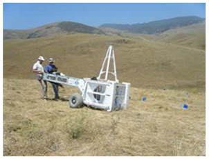
Figure 1. Deployment of the BUD prototype system at the former Camp San Luis Obispo site.
TEMTADS, BUD and MetalMapper equipment was positioned over each detected anomaly (Figure 1). Sufficient data were collected to develop suitable models using custom software from the sensing system developers. Modeling parameters included EM polarizability, which relates to the object's physical size and aspect ratio; EM decay constant, which relates to the object's material properties and wall thickness; and magnetic dipole moment, which relates to the physical size of the object. Although the processing approaches differed in their manner of implementation, all the geophysical models were based on a dipole approximation. A total of 54 dig lists based on 2,588 dig locations were scored.
Results from all demonstrators who analyzed the EM61 data from both a single cart-mounted detection unit and a larger detection array indicated that EM decay of subsurface objects was of primary importance. Inspection of recovered objects revealed that the EM decay constants calculated for advanced sensor operations distinguished TOI from non-TOI much better than did the object size indicated by EM61 data. The advanced sensors provided significantly more accurate estimates of decay-related polarization (Figure 2).
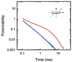
Figure 2. Illustration of the distinctive polarizability of munitions due to their inherent axial symmetry, with one large principal axis response and two smaller but equal responses.
Classification of unexpected TOI was generally successful. One data gap concerned recovery of an unexpected 37 mm projectile in a rocky area that was inaccessible to the EM-61 MK2 array platform. The projectile was correctly classified by the cart-mounted EM61 MK2 but misclassified in the MetalMapper analysis processed by all demonstrators. There also were several cases of missed TOI. Further analysis suggested that these errors could have been avoided through a more rigorous quality assurance project plan (QAPP). Field equipment operators must be equipped with detailed specifications and examples of TOI and with a sufficient quality control process to help determine when an adequate signal to noise ratio has been achieved. Data processors must be similarly supplied with information about unique variations in the TOI.
Overall results of the demonstration showed substantial classification ability of the advanced sensors in a wide mix of TOI, with the best performers correctly classifying all or nearly all of the TOI while reducing by more than 50% the number of non-TOI. For example, analysis of MetalMapper data collected in cued correctly classified nearly 1,000 of the approximately 1,300 non-TOI. Associated analysis of using the MetalMapper system involved development of a cost model based on the collected data and a hypothetical scenario involving 100 acres with 15,000 total detections above the threshold and recovery of 200 TOI. The model suggested that using MetalMapper classification results to guide the diggings, at an assumed dig cost of $90 per target, could reduce the project cost from $1.4 million to approximately $400,000. Similar modeling for a 10-acre site and a $150 dig cost suggested a project savings of approximately $100,000 through avoided digging of every detected object.
In 2014, the U.S. Army Corps of Engineers, California Department of Toxic Substances Control and U.S. Department of Defense collaborated on a follow-up ESTCP project performed at a 7-acre area in a different portion of MRS-05. The project was designed to develop a geophysical classification QAPP and to conduct a post-demonstration treatability study using advanced sensing instrumentation that had recently become available commercially. The project area was selected based on its challenging slope (15-35%) and variable anomaly density (100 to more than 4,000 anomalies per acre).
A primary project objective was to detect all munitions equivalent to a 37 mm projectile to a depth of 30 cm, which is expected to be the most challenging item to detect, classify and remove at MRS-05. Other objectives were to determine at what anomaly density classification process would work best, and whether target selection based on advanced detection rather than amplitude response could provide additional efficiencies. Prior to project start-up, the project team drafted a classification template in accordance with the Uniform Federal Policy for Quality Assurance Project Plan (UFP-QAPP).
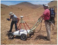
Figure 3. Onsite use of the TEMTADS 2x2 on transects assuming an 0.8-meter footprint.
Due to the steep terrain, cart-mounted TEMTADs 2x2 instrumentation (Figure 3) rather than a tractor-mounted MetalMapper system was used to conduct the detection survey. The study results generally confirmed that advanced sensors provided a richer data set allowing anomaly selection based on source features, such as size and wall thickness, rather than an amplitude response. Approximately two-thirds of the targets meeting the amplitude response metric were removed from the TOI list because they were too small or thin-walled to constitute munitions.
Cued data were collected and processed on the remaining targets. Classification of each target was performed using the intrinsic features (βs) (polarizabilities) derived from the single-source and multi-source inversion processes. Candidate targets were matched to the site's library of candidate TOI. A cluster analysis helped identify signatures that are ubiquitous to the site, and a feature-space analysis identified targets that did not match a specific library entry but were characterized as large, rotationally symmetric and thick-walled.
Through advanced detection target selection and classification, 753 intrusive investigations (4.6% of the 16,202 otherwise required without classification) were completed. Due to overlapping signatures, selection of individual anomalies generally became unreliable in regions with anomaly density greater than 4,200 targets per acre. The treatability study's thorough quality assurance and quality control provided high confidence that all detected munitions within the 5.9-acre area subjected to full surveys and classification were identified, classified and removed. Based on the treatability study results, geophysical classification using the site-specific UFP-QAPP is a viable remedial alternative for the remaining portions of MRS-05. Results of the treatability study were used to update the draft UFP-QAPP template for its application in geophysical classifications performed at other sites.
Environmental Security Technology Certification Program. ESTCP Pilot Program Classification Approaches in Munitions Response San Luis Obispo, California. Final Report. May 2010.
U.S. Army Corps of Engineers Los Angeles District. Final Treatability Study Former Camp San Luis Obispo San Luis Obispo, California. October 2015.
RESOURCES
EPA Website: Military Munitions/Unexploded Ordnance
The U.S. Environmental Protection Agency's (EPA) Military Munitions/Unexploded Ordnance website provides information about EPA collaboration with DoD in defining the inventory of sites and acreage that are potentially contaminated with military munitions and prioritizing those cleanups. The website provides links to EPA and DoD policy and guidance and related reports such as U.S. Government Accounting Office reports addressing cleanup of formerly used defense sites (FUDS) and properties undergoing ownership transfer due to base realignment and closure (BRAC).
DoD Website: Military Munitions Response Program
DoD's Military Munitions Response Program (MMRP) website describes the program's goals of addressing munitions-related concerns such as explosive safety, environmental and health hazards from releases of unexploded ordnance, discarded military munitions, and munitions constituents found at locations other than operational ranges on active and BRAC installations as well as FUDS properties. The website explains the U.S. Army Corps of Engineers role in completing the MMRP inventory of affected installations and properties, describes the process for prioritizing cleanup at MMRP sites, and provides links to DoD guidance documents.
QA Planning: Advanced Geophysical Classification for Munitions Response (AGC-QAPP) Template
DoD's Environmental Data Quality Workgroup collaborates with the Intergovernmental Data Quality Task Force to establish quality assurance project plans that assure consistent and effective protocols for environmental sampling and laboratory testing. The quality assurance project plan for advanced geophysical classification at munitions response sites includes a template designed to facilitate a systematic planning process in accordance with the Uniform Federal Policy for Quality Assurance Project Plans. The task force issued Version 1.0 of the template, as a voluntary consensus document, in March 2016 to assist project teams in planning investigations of buried munitions and explosives of concern at DoD installations and FUDS.
Organizational Accreditation: DoD Advanced Geophysical Classification Accreditation Program
DoD established the DoD Advanced Geophysical Classification Accreditation Program (DAGCAP) to accredit organizations performing advanced classification at DoD munitions response sites. Accreditation provides a unified process through which organizations can demonstrate competency and document conformance to the program requirements, which are based on criteria in the international standard ISO/IEC 17025:2005, General Requirements for the Competence of Testing and Calibration Laboratories supplemented by the DoD Quality Systems Requirements for Organizations Performing Advanced Classification (DoD QSR). The DAGCAP uses third-party accreditation bodies to implement the program and perform assessments.
ITRC Guidance: Geophysical Classifications for Munitions Response
The Interstate Technology & Regulatory Council (ITRC) Geophysical Classification for Munitions Response guidance document explains the process of geophysical classification, describes its benefits and limitations, and discusses information and data needed by regulators to monitor and evaluate use of the classification process. The guidance emphasizes use of a systematic planning process such as EPA's data quality objectives process to develop data acquisition and decision strategies at the outset of a munitions response effort.
CLU-IN Webinar Series: Military Munitions Support Services
The U.S. Army Corps of Engineers' Military Munitions Support Services will host a three-hour webinar on August 4, 2016, to describe use of advanced geophysical classification in remedial investigations and feasibility studies. On October 27, 2016, the series will address classification as part of remedial and removal actions. An overview of the classification process and tools as well as site-specific case studies are available in archives of the initial, April 2, 2016, webinar.
Contact Us:
Suggestions for articles in upcoming issues of Technology News and Trends may be submitted to
Linda Fiedler via email at fiedler.linda@epa.gov.
Past Issues:
Past issues of the newsletter are available at http://www.clu-in.org/products/newsltrs/tnandt/.
Archives | Subscribe | Change Your Address | Unsubscribe
