Geotechnical Sensors
- Direct-Push Technologies
- Explosives
- Fiber Optic Chemical Sensors
- Gas Chromatography
- Geophysical Methods
- High-Resolution Site Characterization (HRSC)
- Immunoassay
- Infrared Spectroscopy
- Laser-Induced Fluorescence
- Mass Flux
- Mass Spectrometry
- Open Path Technologies
- Passive (no purge) Samplers for Groundwater
- Test Kits
- X-Ray Fluorescence
Introduction
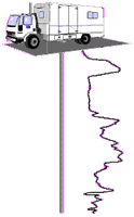 Cone penetrometer rig. Courtesy of Gregg Drilling. |
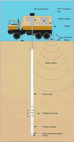
Direct-push platforms have gained widespread acceptance in the environmental industry over the past decade because of their versatility, relatively low cost, and mobility. Using the weight of the truck in combination with a hydraulic ram or hammer, a tool string is pushed into the ground.
Description
The two major classes of direct-push platforms are cone penetrometer (CPT) and rotary hammer systems. The distinction between these units is that CPT units advance the tool string by applying a hydraulic ram against the weight or mass of the vehicle alone, while rotary hammer units add a hammer to the hydraulic ram to compensate for their lower mass. These platforms share the same principle of operation, similar tools, and a number of advantages and limitations. They differ in scale, application, and to some extent the types of instruments and tools that have been developed for each. For these reasons, CPT and rotary hammer platforms fill different niches in the environmental field. CPT rigs can generally push to greater depths and push larger-diameter rods; they allow sampling from depths that are inaccessible using rotary hammer rigs. Rotary hammer rigs are smaller, more portable, and require less training to use; they allow samples to be collected from places, including inside of buildings, that are inaccessible to a CPT rig. Although they are sometimes limited in the depths to which they can penetrate, some of the smaller rotary hammer units can be anchored to the ground using earth augers to add to the reaction mass of the vehicle alone. In addition, rotary hammer rigs can also penetrate some hardened sediments that are impenetrable to CPT devices.
In general, types of sampling tools and methods of sampling are very similar; when a new technology is developed for one system, it is usually adapted for the other. For more detail about how direct-push technology works, see the Direct-Push Platform encyclopedia entry.
Typical Uses
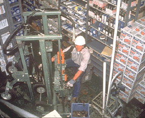 Hand truck rotary hammer rig. Courtesy of Precision Sampling. |
Geotechnical sensors can provide information about the physical properties of the subsurface environment, for example, density, competence, and thickness of layers of soil or sediment. Sensors can provide information about stratigraphy, estimate depth to groundwater, or approximate hydraulic conductivity. An investigator must understand the properties and structure of soils and sediments to characterize a site accurately, as these conditions will affect sampling strategies and selection of technologies. Knowledge of the subsurface will also be critical when determining the location, extent, fate and transport, and attenuation of subsurface contaminants.
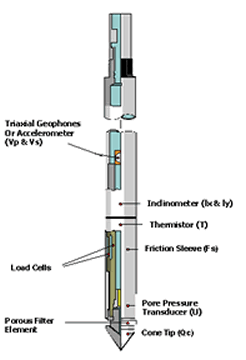
Well-logging instruments have been standard geotechnical tools for nearly a century, developed initially to characterize petroleum reservoirs. The Schlumberger Oilfield Glossary provides additional definitions and information for most of the terms in this section, as well as those associated with many other downhole applications. In the years since their initial development, many of these tools have been adapted for environmental and water resource applications. Although there are many commercially-available sampling devices developed for both the CPT and rotary hammer systems, there are a few basic varieties of sampling tools with a wide range of technical enhancements. Tool sets include those that make use of measurements of pressure, electrical resistivity, and seismic properties, as well as visual observations. In the most sophisticated systems, these tools can be stacked to analyze several parameters simultaneously.
Pressure Tools
 |
|
Combined
cone penetrometer and piezocone. Courtesy of Gregg Drilling.
|
Geotechnical tools that use pressure to investigate the subsurface can be divided into two types: lithostatic pressure (cone penetrometer) and hydrostatic pressure (pore-pressure transducer) instruments. In both cases, the force of the advancing probe is used to apply pressure to the soil and sediment and to any groundwater held in pores. The resulting resistance to the probe is measured to provide information about physical properties. These tools are usually used together as part of a stacked system. In general, because of the greater mass available using CPT technology, these tools have been more widely developed for CPT rigs. However, some rotary hammer developers are beginning to adapt pressure tools for use with lighter rigs.
Lithostatic Pressure Sensors
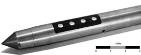
Cone penetrometers make use of sensors in the cone tip to measure soil and sediment resistance to penetration (tip resistance). Tip resistance is a measure of the pressure exerted (force per area) on the tip of the cone as it is advanced at a constant speed. Cone penetrometers also measure the amount of friction (sleeve friction) on the sides of the probe rods. Sleeve friction is the sum of friction and adhesion on the side of the rods when advanced at a constant speed. Friction and pressure sensors inside the cone are usually connected to a data acquisition system on the surface, either using cables or data transmitters. Using on-site computers, data from the sensors can characterize soils and aquifer materials before the samples are collected.
Different types of materials respond differently to the advancing cone. Using the amount of tip resistance, soil or sediment type can be inferred. In general, fine-grained materials such as clay and silt create less tip resistance, whereas coarse materials such as sand and gravel create more tip resistance. This classification can be further refined by comparing the amount of tip resistance to the relative amount of sleeve friction. Greater amounts of sleeve friction are associated with more consolidated materials such as hardpan or more cohesive materials such as clay. There is not a unique relationship between tip resistance, sleeve friction, and soil type, and a number of classification systems have been developed.
Hydrostatic Pressure Sensors
Pore pressure transducers, also known as piezocones, measure the response of groundwater in pores in soil or sediment to the force of the advancing point. When impermeable materials such as clays are compacted, their pore fluids cannot easily escape, leading to anomalously high fluid pressure within the pore. Pore pressure can then be used to estimate the hydraulic conductivity of the materials. When the probe is not advancing, the same sensors can be used to measure the pressure head at a given location.
The tool itself consists of a fluid-filled chamber enclosed by a permeable membrance. A pressure sensor in the tool rod senses changes in the chamber fluid caused by the higher-pressure pore fluid. As with cone penetrometer tools, the pressure sensors in a pore-pressure transducer are connected to surface data acquisition systems.
Electrical Resistivity Tools
 Electrical conductivity probe with Wenner array electrodes. Courtesy of Geoprobe Systems. |
Direct-current (DC) resistivity and conductivity sensors measure the apparent ability of soils and sediments to conduct an electrical current. This property varies with soil or sediment type, and it is often used in conjunction with data from pressure sensors to further refine soil stratigraphy measurements. During resistivity surveys, electrical current is passed into the earth through a pair of current electrodes on the surface of the tool. A second pair of electrodes (potential electrodes), also on the tool surface, measures the resulting difference in voltage as the current travels through the ground, and the apparent resistivity is calculated.
The resistivity of soils is a complicated function of porosity, permeability, the ionic content of pore fluids, and degree of clay mineralization. As a sideline, drastic differences in apparent resistivity may be noted when the probe encounters free product, providing an indication of contamination; this technique was initially for petroleum exploration. The apparent resistivity is the bulk average resistivity of all soils influencing the flow of current. It is calculated by dividing the measured potential difference by the input current and multiplying by a geometric factor specific to the array being used and the spacing of the electrodes. Different kinds of tools use different arrangements of current and potential electrodes for different applications. Examples are the dipole-dipole, Schlumberger and Wenner arrays.
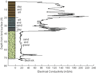 |
| Electric
log generated using rotary hammer rig with associated stratigraphy. Courtesy of Kansas Geological Survey. |
Although resistivity surveys are dependent on the type and amount of pore fluid, soil types can be inferred from the data. Because of their greater clay mineral content (and the associated charged surfaces) and lower permeability (resulting in a higher ionic content in pore water), clays and silts are generally more conductive. Sands and gravels usually have more dilute pore water and fewer charged surfaces and, as a result, are less conductive.
Seismic Tools
 Seismic cone test. Courtesy of Fugro Company. |
Seismic survey technologies are based on the principle that a portion of acoustic energy introduced into the ground at a specific location is reflected back to the surface when materials of different density are encountered. Sources of acoustic energy include power-assisted hammers, dropped weights, or explosive charges (such as shotgun shells). The acoustic waves travel into the ground at a velocity dependant on the density and elastic properties of the material through which they travel. When the waves reach an interface where the layer velocities change significantly as a result of changing physical properties, a portion of the energy is reflected back to the surface, and the remainder is transmitted into the lower layer. Where the velocity of the lower layer is higher than that of the upper layer, a portion of the energy is also critically refracted along the interface. Critically refracted waves travel along the interface at the velocity of the lower layer and continually refract energy back to the surface.
Geophone arrays determine the time of travel. The angles of reflection and refraction are determined from arrival information. Using this information, the position of geologic units may be determined. With CPT seismic sensors, seismic waves are generated at the ground surface using a beam attached to the CPT rig. Geophones in the cone recognize the arrival of waves generated at the ground surface. Software then plots the wave amplitude versus travel time, and wave velocities are calculated. The seismic sensor may be used to measure compression and shear wave velocities for layers of known depth and thickness. These factors are key parameters for the analysis of soil behavior in response to dynamic loading from earthquakes, ice, vibrating machine foundations, waves, and wind.
Video Imaging Tools
Several downhole video imaging systems have been developed for direct push probes by government and commercial developers. These systems allow viewers to characterize lithologic properties, map significant fracture patterns, and confirm the presence of gross free-product contamination in the subsurface. These systems are designed to be used as a cross-check against other geotechnical sensors such as tip resistance, sleeve friction, and DC resistivity. Investigators are able to visually inspect ambiguous or very thin soil features or potential contaminant layers, reducing the requirements for soil sampling and saving time and money.
These systems use miniature video cameras with magnification and focusing lens systems integrated into the probe to obtain images of soil. Light-emitting diodes provide illumination; in some systems, laser-induced fluorescence probes can be used to image contaminant globules. The signal from the camera is sent to the surface where it can be viewed in real-time on a video monitor, recorded on a standard videocassette, or digitized for further analysis. With 100x magnification factor, objects as small as about 20 micrometers (1 millionth of a meter) can be resolved on a standard 13-inch monitor. Some firms are developing algorithms to classify soils electronically from the video image.
 Examples of clean sand (first and second from left) and sand contaminated with coal tar. Images taken with a direct push video sensor. Courtesy of Applied Research Associates. |
Stacked Tools
The most useful geotechnical tools make use of multiple, stacked instruments. Output from these tools allows a geologic cross-section format that shows the various instrument measurements at the same relative depth. Multiple interpretations are possible for any one instrument. Presenting the data in this format allows the analyst to cross-check data from several instruments.
 |
| Example of output from stacked geotechnical sensors. |
Advantages
Direct-push technologies are particularly well suited for application of the Triad Approach to site investigations, for sites with shallow subsurface contamination in unconsolidated soils and sediments. The Triad Approach makes use of on-site analytical tools, in conjunction with systematic planning and dynamic work plans, to streamline sampling, analysis, and data management conducted during site assessment, characterization, and cleanup. Field analysis in general and direct-push systems in particular are often used to speed collection and reduce costs on projects where the sites are large, a high volume of data points are needed, the sites are partly or totally inaccessible by a large drill rig, or to minimize sampling disturbances in sensitive habitats.
In general, direct-push techniques are quicker and more mobile than traditional methods. Sampling and data collection are faster, reducing the time necessary to complete the investigation and increasing the number of sample points. Investigations are less invasive, and these platforms offer the ability to perform many functions downhole, often multiple functions and at multiple depths within the same boring. Direct push geotechnical sensors allow the investigator to gather rapidly a great deal of information on subsurface conditions, including profiling soil types, estimating hydraulic conductivity, and even gathering construction and engineering parameters.
In particular, the use of direct-push platforms to deploy geotechnical sensors also conveys a number of advantages. The continuous nature of many instruments provides more complete coverage than many traditional methods, such as logging drill rig cuttings, and is much faster than visually logging soil cores. Stacking multiple instruments allows the user to cross-check geotechnical data from several instruments, increasing the accuracy of soil classifications and identification of contaminant migration pathways while simultaneously characterizing contaminant distribution.
Limitations
Direct-push platforms and technologies do have some inherent limitations. Practical vertical sampling depth limits are about 60 feet for rotary hammer rigs and 100 feet for CPT rigs. Direct-push technologies generally are limited to unconsolidated materials and, in general, are limited to depths of less than 100 feet. They cannot be used to penetrate rock layers, thick (greater than 1 foot) concrete footings or foundations, or other high-density barriers. Large changes in density between stratigraphic layers can also limit the use of these technologies. The presence of soft layers overlying hard layers can cause alteration in the alignment of the probe and, ultimately, the bending or breaking of the rod.
Geotechnical analysis using direct-push platforms has its own set of particular limitations. Conclusions about soil type based on tip resistance and sleeve friction should always be calibrated with actual soil samples that are representative of the range of materials present on the site. Analyses such as grain-size evaluation from soil samples to determine porosity and permeability and slug tests to quantify hydraulic conductivity in the saturated zone follow rigorous and well-accepted standards for classification. Although many direct-push geotechnical methods are proven techniques based on extensive use in traditional boreholes, the classification methodologies and standards may vary. Variation in operator techniques may reduce the precision and accuracy of some geotechnical data. For example, cone penetrometers and pore-pressure transducers depend on a constant rate of advance to translate pore-pressure and tip-resistance into permeability and grain-size.
Cost Data
Studies indicate that direct-push systems may provide significant savings over conventional site assessment and characterization methods. Cost information varies greatly among the different technologies as well as for projects of different scope. The sites listed below provide information about the costs associated with a variety of technologies.
Additional Resources
Applied Research Associates, Inc.
Fugro Company
Geoprobe Systems
Gregg Drilling
Kansas Geological Survey
Multidisciplinary Center for Earthquake Engineering Research
Pacific Northwest National Laboratory, Vadose Zone Transport Studies
Precision Sampling, Inc.
Schlumberger Oilfield Glossary
Spectrum Geophysics
Click here to download QuickTime™ video player.
